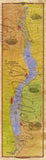
A New Map of Lake Pepin by Lisa Middleton … Order Today!This fine art print of A New Map of Lake Pepin features named islands and sloughs and is both geographical and historical in nature. Landmarks visible to those cruising on both road and river are marked from Wabasha to Red Wing. Approx. 36″ long, and beautiful when framed. You may study a large high-resolution image by visiting our ART GALLERY HERE.
 A New Map of Lake Pepin by Lisa Middleton … Order Today!