Tundra Swans are once again flowing south along the Mississippi River and can be seen by the hundreds from the Trempealeau Refuge area to south of Goose Island County Park (La Crosse, Wisconsin, Brownsville, Minnesota, to Stoddard, Wisconsin.) Be certain to keep your eyes open for ducks, pelicans, and occasionally, a pair of Trumpeter Swans.
Find much more detail about the Fall Migration and peak dates by typing “Tundra Swans” or “Trumpeter Swans” or “Pelicans” in the Search Box to the upper right of this Web Page!! You might also do a search of our EAGLE articles! We have been making notes about the spring and fall migration for nearly 20 years!
The Swans and Pelicans will be around until the bays and the main channel ice over. Then American Bald Eagles will begin gathering in quantities around any open water just below the Dams. It is a great time to meander along the river, view eagle nests, eagles, and our lovely little towns along the river. Bring your Binocs!
WISCONSIN — A number of counties in Minnesota and Wisconsin are reporting flood conditions, as rainfall remains in the forecast.
What You Need To Know Wisconsin’s northwestern neighbors are now seeing major flooding. Concern is now creeping into parts of Wisconsin along the Mississippi River where water levels are high and continuing to rise
As of Tuesday afternoon, the NWS forecast showed the river was still climbing in La Crosse and would likely crest at some point Wednesday at around 15-feet, which is roughly six inches below major flood stage
Just south of La Crosse, in Vernon County, emergency management said its biggest concern is what more rain will do to the Mississippi Over the weekend, parts of Minnesota were on high alert as flood levels continued to rise in many areas after days of unrelenting rain.
Wisconsin’s northwestern neighbors are now seeing major flooding. Concern is now creeping into parts of Wisconsin along the Mississippi River where water levels are high and continuing to rise.
In Hudson, Wis., many businesses and homes along the waterways are already seeing flooding nearby.
Data from the National Weather Service (NWS) showed the Mississippi has crested upriver in Minnesota, with river levels falling in St. Paul and Red Wing.
As of Tuesday afternoon, the NWS forecast showed the river was still climbing in La Crosse and would likely crest at some point Wednesday at around 15-feet, which is roughly six inches below major flood stage.
Just south of La Crosse, in Vernon County, emergency management said its biggest concern is what more rain will do to the Mississippi.
“Seeing what the next week is going to do,” Brandon Larson, with Vernon County emergency management, said. “We are in contact with the weather service and their hydrologist to keep an eye on their predictions and what it’s doing up north. That’s kind of where we are at right now and staying in touch with the fire departments that are along the Mississippi.”
Larson said with the holiday weekend approaching, people need to be careful when getting out on the water.
“It is a lot more dangerous,” he said. “The flow of water is a lot faster. The current can take you in a quick hurry and what you are used to with the normal river levels is not the case right now.”
Right now, it’s a waiting game to see just how much more rain will fall along the Mississippi as we head into the holiday weekend.
Hi Friends and neighbors, very shortly we will be putting our property 1.25 miles east of Stoddard up for sale. This is a heads up, in case you have a friend or relative looking for a beautiful south-facing property in Wisconsin’s Driftless region just 12 miles south along the Mississippi from downtown La Crosse.
The house overlooks a beautiful and varied 54-acre domain of woods, meadow, pristine spring-fed marsh, robust artesian well and hillsides. Fish the property’s 1 mile of frontage along Coon Creek…one of Wisconsin’s most lauded trout streams. The bottoms provide beautiful and silent cross country skiing.
South facing decks on two levels of the bungalow style home and an insulated 3 season room provide beautiful vistas of bluff and valley to south, east and west year around.
The historic 1912 barn stands straight and tall, has a dry hay loft, 2 horse stalls. Great as a walk-in barn for horses or storage for toys and tools. Artesian well just below the house and barn. Historic buggy shed offers a dry home for horse tack, or any other collection that is dear to your heart. Excellent pasture or hay in the meadows, or firewood from the woodlot. Wild grapes and a 35 yr old apple tree as well as perennials make even the yard productive.
Neighbors practice quality deer management so plan your hunt for the big buck! Or watch the hunt from the sun porch or decks! The wetland meadows provide a natural refuge with nesting sandhill cranes, playful otters, muskrats, resident eagle, and fawns are raised annually on the homestead hillsides. Watch Turkeys strut as well as pheasants, trumpeter swans and Virginia Rail which populate your piece of the Mississippi River valley. Listen as Tundra swans fly low to land between Stoddard and Goose Island.
Visit this link on Lisa’s Facebook page for many more pix!
3 bedrooms, 2 bath home of approx 2500 sq ft. 2 car garage. High topped boat/RV storage off the barn. Hardwood floors throughout the main floor. Finished walk-out basement with family space, laundry, a huge office space. New heat pump, furnace and kitchen appliances. All systems work as they should. Fireplace in living room. Wood stove in basement. Both with stainless steel chimneys. Large open kitchen. New roof on house and barn.
Upstairs is finished with bedroom suite, 1/2 bath, walk in closet. Large attic space is unfinished.
Owner may accept, counter offer, or refuse any offer. Sold as is. Look for more pictures on Zillow (address W987 Cedar Valley Road, Stoddard, WI 54658) or the public Farm for sale album on Lisa Middleton’s facebook page noted above.
Call Rich 309-200-7473 or text Pat at 608-385-2510 for more info (including a map) or to visit the property. Suggested pricing $675,000-$720,000.
Nearly the entire sideyard is shaded by the great oak.
The Tundra Swans have returned immediately on the tail of one of the most glorious fall displays ever along the Upper Mississippi! And we are expecting a beautiful two weeks of Indian Summer to welcome them back to Pool 8!
So right now is prime time for Swan viewing between La Crosse and Stoddard, Wis. or south of La Crescent to south of Brownsville, MN. Both Wisconsin and Minnesota offer scenic waysides south of La Crosse.
Tens of thousands of swans will stop to rest and feed in shallow open water in the next two weeks. Use your binocs and notice that the American White Pelicans are also here among the swans. If you see a few groups of large 2-4 swans, they are most likely TRUMPETER SWANS. The grayer swans are this year’s cygnets. Many of the swans seen now are family groups, so there will be many young among the flocks.
Leaves have pretty much fallen, so Eagles will seem abundant. Watch for huge black nests and eagle “snags”, dead trees for fishing that eagles will use year after year! It’s a great time to be on the river!!
Much more information from previous posts can be found by using the SEARCH button and such key words as: Tundra Swans or Trumpeter Swans or Pelicans or ducks. Also visit our interactive map measuring the density of bird migration along the Mississippi River Flyway!!
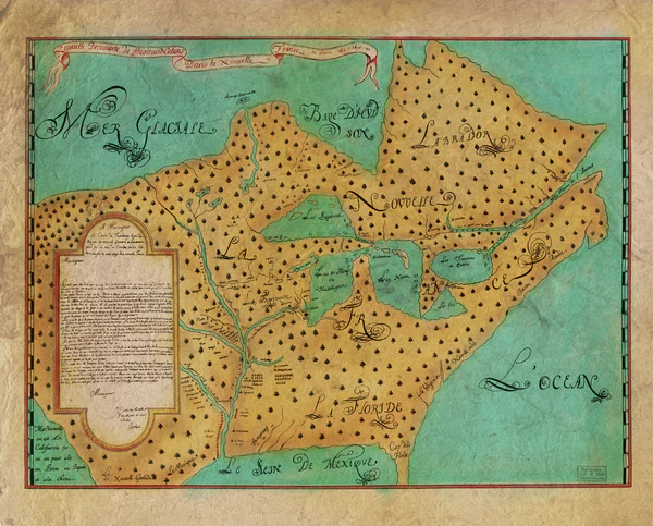
350 years ago, the course of history was changed forever. In May of 1673, Father Marquette and explorer Louis Jolliet set out from Green Bay, Wisconsin and traveled along waterways from the Great Lakes to the Mississippi River. This expedition, when many cultures met for the first time, opened commerce and transportation routes still used today.
This summer, from June 16th to June 18th, Prairie du Chien and Crawford County, Wisconsin celebrate the deep and continuing regional history represented by this expedition. The 350th Expedition Celebration offers the opportunity to better understand our region’s rich history. A history that began with the many native nations who lived on this land for centuries before the French explorers saw it for the first time. At the celebration, you will experience historical reenactments by the voyageurs and performances from native nations.
This 2023 celebration commemorates the 350th anniversary of Marquette and Jolliet’s expedition reaching the Mississippi River at Prairie du Chien. Come and experience this historic anniversary. In addition to the historical reenactments and native american performances, event go-ers will enjoy the Prairie Villa Rendevous, flea market, farmer’s market, old-tyme photo opportunities, carriage rides, ax throwing, flint knapping and other historical demonstrations and displays, medallion hunt, old-time kids games, carnival performances (juggling, stilt walkers, hula hoop workshop), historical tours, parade, music, fireworks, food and so much more. (TRAVEL WISCONSIN)
In addition to the Expedition Celebration, the third annual FHC conference will be held in Prairie du Chien from June 15-17. I believe anyone may register for a series of fascinating historical presentations. Events list follows:
June 15, 2023: Full-day Conference and buffet lunch at The Barn, 32800 County Road K
June 16, 2023: Full-day of guided site visits led by Mary Elise Antoine, FHC WI Ambassador and President Emeritus of the Prairie du Chien Historical Society
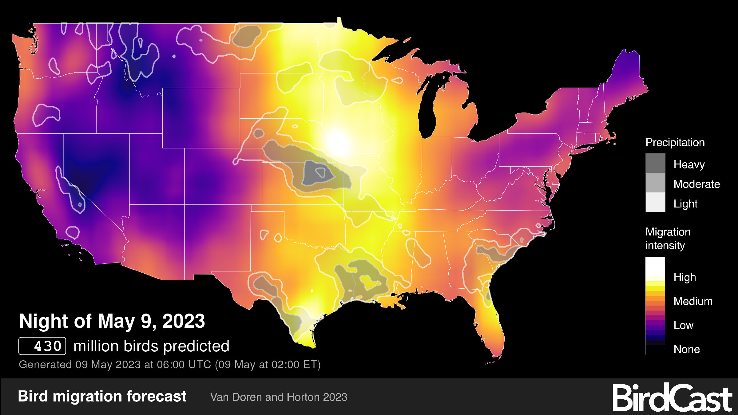
Another interesting Interactive map that shows a HIGH MIGRATION INTENSITY right through the Upper Midwest! Tracking will end June 15. Refresh page to get an updated image, or check this page: https://birdcast.info/
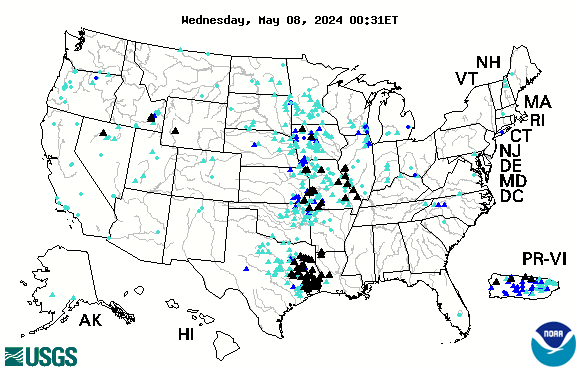
Below is the USGS interactive map that provides REAL TIME info on which Rivers in the US are cresting. The map below is accurate every day. Black Triangles indicate flood stage. Looking to compare stats with the Flood of 1993? CLICK HERE.
See more interactive maps by clicking the category in the list to right: INTERACTIVE MAPS.
What a difference a month makes! Temps are settling in the 40s one week, 70s next, and then back to 40s! Snow accumulates, then melts, then falls again. Our great Mississippi rises, then falls, then floods! Just now, the crest is slipping from La Crosse into Iowa, but hover close to moderate flood levels everywhere.
Many parks are still closed, but birds are still moving along the Mississippi River flyway. They are, however, moving in fits and starts along with inclimate weather and high water. Their one necessity is the availability of food along the route. With another round of nice weather approaching Wisconsin and Minnesota, birds should be back on the move!
Our Sandhill nest is full of activity as the eggs hatched on April 29 – about a week early. Eagles are busy with their own fledglings, so check out nests for the white heads of adults busy with bringing food to the nests. Egrets and Great Blue Herons have arrived and are visible in ponds and sloughs not directly on the flooded Mississippi River. White pelicans also are checking out the smaller wetland ponds along the flooded river. We see them frequently.
Riverboats, including the Twilight, the newly restored Julia Belle Swaine, and the La Crosse Queen are all eager to start their seasons “come hell or high water!”
I will be posting several links just to remind you of what you can find on our Mississippi River at this time of year, and also on greatriver.com While I no longer post daily, our archives are filled with seasonal information!! Use the Search Button above or search through our CATEGORIES! And Happy Spring!
Between thunderstorms, Winter Snow Warnings, and now Sunshine! I’ve been wondering what the response of our (mostly) migratory waterfowl would be over the course of the last day or two. Viewing has been great from Goose Island south to the Bay immediately north of Stoddard, along Hwy 35. Big white swans on their own in pairs are most likely Trumpeter Swans, while the migratory Tundra Swans will be visible in large numbers. If you see a thick cluster of large white birds, check closely for the large bill, heavy body and short neck of the pelicans.
All the waterfowl have been passing through for 2-3 weeks, as well as the mass of migratory ducks. Bring your bird guide to ferret out the many species of Dabbling (shallow water) ducks and Diving ducks (bigger, deeper areas) you are bound to see. Bald Eagles are abundant and Sandhill Cranes are pretty much settled into their nesting territories now and are busy calling to one another.It’s a wonderful time of new life on the river!
This is just to let your know that while White Pelicans still abound, they are clustered up in tight pods wherever they can get out of the wind. Check your favorite Eagle nests…those I like to watch all still have adults in them, but I did have a report that during one of our sleet storms a nest was abandoned. No Tundra Swans, of course, but there are Trumpeters! Walked through Goose Island and many of our spring waterfowl are still here. Eagles are abundant, indeed. Sandhill Cranes on their nests. Beaver, muskrat, even herons are out and about. Find them sheltering from the wind and looking for some of the warmer weather forecast for next week.