Skip to primary content
Skip to secondary content

Ramblin’ On

Mississippi River Heritage, Natural History, and Recreational observations from author Pat Middleton. Welcome!

Ramblin’ On

Main menu

  • Home
  • About Great River Publishing
  • GREATRIVER.com
  • Introducing Lisa Middleton Maps
  • SHOPPING
  • Small Boat Cruise Reviews

Tag Archives: USGS Flood Map

Real Time Flood Watch

Posted on April 8, 2008 by admin
Reply

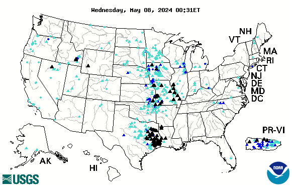
Below is the USGS map that provides REAL TIME info on which Rivers in the US are cresting. The map below is accurate every day. Black Triangles indicate flood stage. Looking to compare stats with the Flood of 1993? CLICK HERE.
us

Posted in Flooding, Lower Mississippi | Tagged USGS Flood Map | Leave a reply

Categories

  • Belize & Guatamala
  • Bird Migration Forecast map
  • birding
  • Boating the Mississippi
  • Earthquake Report
  • Fall Color Interactive Maps
  • Feature Story Archives
  • Find Vesse
  • Find Vessel
  • Fishing
  • Flood Alerts
  • Flooding
  • Galapagos
  • General
  • Historic Hand-Painted Maps
  • historic maps
  • INTERACTIVE RIVER MAPS
  • Kindle Pamplet Books
  • Lower Mississippi
  • Mexico
  • Monarchs Migrate August/September
  • Natural disasters
  • northwoods
  • Questions Questions
  • Railroading History
  • Ramblin'
  • Sandhill Cranes
  • SEARCH GREATRIVER.com ARCHIVES
  • small boat cruise
  • Spiritual
  • Steamboating
  • Tourism Announcements
  • Tourism/Fall Color
  • Train Journeys
  • travel
  • Travel Mexico!
  • treasure hunting
  • Treasure Hunting
  • Uncategorized
  • Upper Mississippi
  • white phase

More on Tundra Swans

We have many posts on Tundra Swans and Pelicans! Use the search button top-right to ferret them out!

Click on any link below to return to the Mississippi River Home Page

Proudly powered by WordPress