Tundra Swans, Pelicans, Eagles and Dabblers and Divers Make Their Move!

The Tundra Swans have returned immediately on the tail of one of the most glorious fall displays ever along the Upper Mississippi! And we are expecting a beautiful two weeks of Indian Summer to welcome them back to Pool 8!

So right now is prime time for Swan viewing between La Crosse and Stoddard, Wis. or south of La Crescent to south of Brownsville, MN. Both Wisconsin and Minnesota offer scenic waysides south of La Crosse.

Tens of thousands of swans will stop to rest and feed in shallow open water in the next two weeks. Use your binocs and notice that the American White Pelicans are also here among the swans. If you see a few groups of large 2-4 swans, they are most likely TRUMPETER SWANS. The grayer swans are this year’s cygnets. Many of the swans seen now are family groups, so there will be many young among the flocks.

Leaves have pretty much fallen, so Eagles will seem abundant. Watch for huge black nests and eagle “snags”, dead trees for fishing that eagles will use year after year! It’s a great time to be on the river!!

Much more information from previous posts can be found by using the SEARCH button and such key words as: Tundra Swans or Trumpeter Swans or Pelicans or ducks. Also visit our interactive map measuring the density of bird migration along the Mississippi River Flyway!!

Nationwide Fall Leaf Map

Fall Foliage Hot Lines from greatriver.com 
While mid-October seems to be the time when Fall Foliage really POPS along the Upper Mississippi River, we on the Upper River are certainly already seeing brilliant red sumacs. Softwoods are starting to yellow up. You can follow the southward march of Fall Color with the contacts below. Weather is perfect, enjoy the drive!

Try this new 2021 Interactive Fall Color Prediction Map for the entire US! It says Smoky Mountains, but it is actually the whole country in great detail!

Fall Foliage Prediction Map for Wisconsin

More Fall Foliage Hot Lines from greatriver.com 
While mid-October seems to be the time when Fall Foliage really POPS along the Upper Mississippi River, we on the Upper River are certainly already seeing brilliant red sumacs. Softwoods are starting to yellow up. You can follow the southward march of Fall Color with the contacts below. Weather is perfect, enjoy the drive!

Arkansas.  https://www.arkansas.com/arkansas-seasons/fall (late October to early November)

Illinois.  800-226-6632; www.enjoyillinois.com (early October)

Kentucky. 800-225-8747;  (late October)

Minnesota. 800-657-3700; www.exploreminnesota.com (late September to mid-October)

Missouri. 800-778-1234; www.missouritourism.org (mid-to-late October)

Tennessee. 800-697-4200; Fall Folliage Predition Map (early November)

Wisconsin. 800-432-8747; www.travelwisconsin.com (early through mid-October)

  • And don’t leave home without the indispensable guides to Mississippi River and Great River Road travel! Every volume of DISCOVER! America’s Great River Road is filled with a variety of fascinating Mississippi River fact and lore.  Photos, maps, charts!  All Volumes contain info on birding, wildlife viewing hotspots. Each highlights Geography, interpretive history and natural history attractions along the Great River Road.

Click HERE to Purchase Discover! America’s Great River Road… St. Paul, Minnesota,  Discover! Guides are available in four volumes from St. Paul to Venice, Louisiana

Also available on Amazon as paperback ($22) or KINDLE guide (9.99).  Or phone 888-255-7726 and we will send you your copy TODAY.

BIRD CAST from Cornell Ornithology

MIGRATION TOOLS

ACTIVEForecasting ends Nov 15, 2021

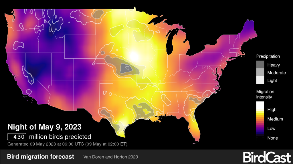
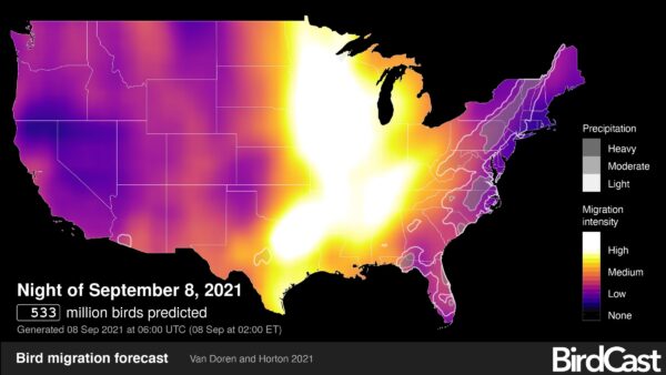
How fun is this! Cornell offers a migration forecasting tool for the annual bird migrations. The 2021 Fall Migration is ongoing and these interactive maps offer an image of data collected from radar that also forecasts the weather. Each map below is current and provides a slightly different piece of data for the next three days (and nights). You can find the maps on the CORNELL SITE Here!

It appears the peak evening thus far was Sept 8, 2021, with 1/2 a billion birds in flight. Just look at how intense the migration was over the Mississippi River!!!!

FORECAST AND ANALYSISA picture is worth 500 million birdsBy Andrew Farnsworth The Cornell Lab Sep 08, 2021

The BirdCast forecast model predicts just over half a billion birds to be flying during peak flight hours tonight! Turn out your lights! Go birding! 

Bird migration forecast maps

 Learn more

Forecast map: Day 1
Forecast map: Day 2
Forecast map: Day 3

Local bird migration alerts Click and enter a city name to get local alerts!

Forecast map: Day 3

Local bird migration alerts

Search with our local migration alert tool to determine whether birds are passing overhead near your city tonight!  Learn more

Live bird migration maps

See real-time analysis maps of intensities of actual nocturnal bird migration, as detected by the US weather surveillance radar network between local sunset to sunrise. Cornell Lab of Ornithology currently produces these maps. Play live bird migration maps

Exploring the Galapagos Islands!

WATERWAY CRUISE REPORT

The Galapagos Island cruise reports are among our most popular Waterway Cruise Reports.. .

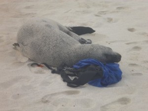
The best part of traveling the Galapagos is an amazing up close and persoal experience with the wildlife who call it home. This seal really loved my backpack!

PART TWO of OUR WATERWAYS CRUISE REVIEW OF VISITING THE GALAPAGOS ISLANDS…. Click HERE to read PART ONE.

Alex was our preferred naturalist… mainly because of his love of the islands, and because of his 20 years of experience! But for those whose personal perspective is that this was a “vacation” and no “mandatory learning” was allowed, we had a second naturalist whose main focus was “learn a little” and have a great time! Every Galapagos naturalist today is professionally trained to interpret and protect this unique natural heritage.

On my first open ocean snorkeling excursion, I panicked and clung to the ladder.

“Alex,” I urged, “don’t wait for me. I’ll just hang here for a while.”

“I don’t go anywhere unless you decide to come with me, or get back in the boat,” he explained. “I don’t leave you in the water alone.” I felt absolutely safe with Alex from that point forward.

Snorkeling, panga rides, and kayaking were all available options for daily water-based activities. Snorkeling was by far the most popular… Turtles, white-tipped sharks, swimming with sea lions, and even “circling-up” when visited by several hammerhead sharks provided highlites on our Galapagos cruise. Oh yes, and we were joined by a pod of leaping dolphins during one of many memorable panga excursions!

“I really could not believe it was ME out there snorkeling with Hammerhead sharks!” one Minnesota passenger exalted.   And sea turtles were ABUNDANT in the clear waters!
 

Twice each day, the naturalists led us ashore for an island hike. An afternoon nap was mandatory, so that everyone had the energy to do the really important stuff… like hiking among the booby’s and iguanas, and magnificent Frigate Birds.

The AMAZING thing is  that these creatures truly have no fear of humans!! It was as if we had entered into the Garden of Eden.

While it is not necessary to  be   a student athlete to visit the Galapagos Islands, for the first time on any cruise, we found ourselves to be among the older visitors, rather than the younger!

It IS necessary to be able to hike for a mile or two… some of it over rocky lava surfaces, or up and down short steep slopes.

“Wet landings” are common, so be prepared to swing your legs over the side of a rubber panga and in the gentle surf!

I did bring two pieces of “gear” that I found incredibly useful…trekking poles that could be unscrewed to fit in a small carry-on suitcase, and lightweight Salomon’s “Amphibian” style hiking shoes with webbing. The trekking poles worked great when we were on lava rocks.

The specialized water/hiking shoes were great for wet landings. The webbing meant shoes dried quickly. The hiking soles stuck like glue to wet rock and afforded comfortable cushioning for the rest of the hike.

Casual dress is definitely the order of the day for this cruise!

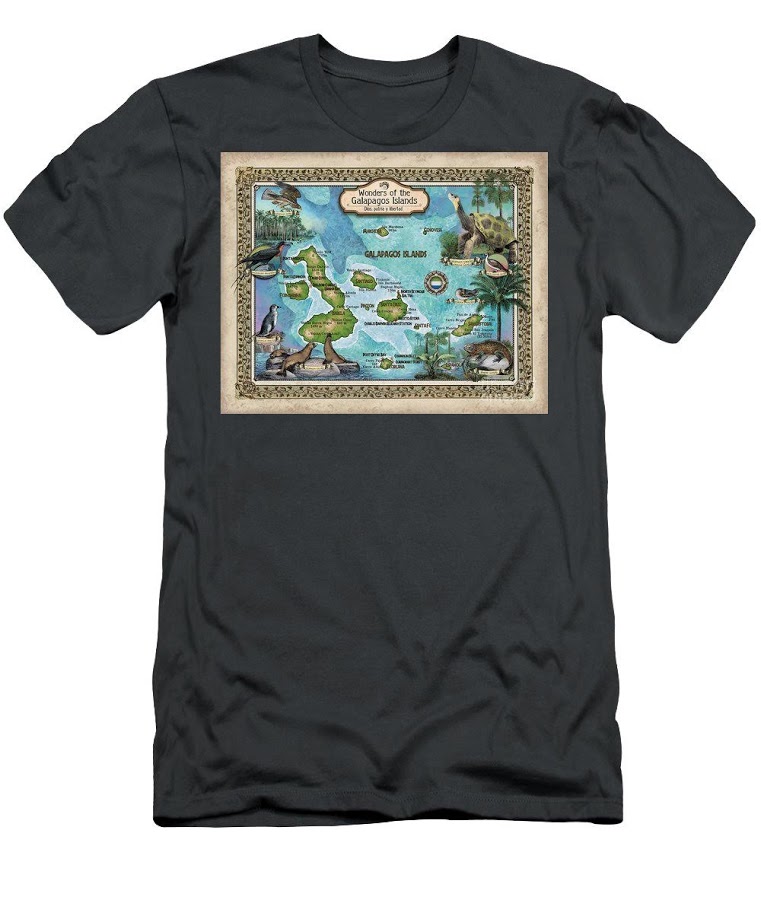
Lisa’s beautiful maps are also available on Textiles!! If you are planning a wedding, family reunion or other activities on a tropical island, textiles make great gifts for the whole group!!  Click this link to see Options!

Drainage Map of the Mississippi River and its Tributaries. Some Facts and Figures

QUESTIONS! QUESTIONS!
For Jack, who wants to know more about all the tributaries of the Mississippi River: how many there are,  their names, and how long they are!
NPS.gov watershed tributaries

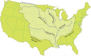
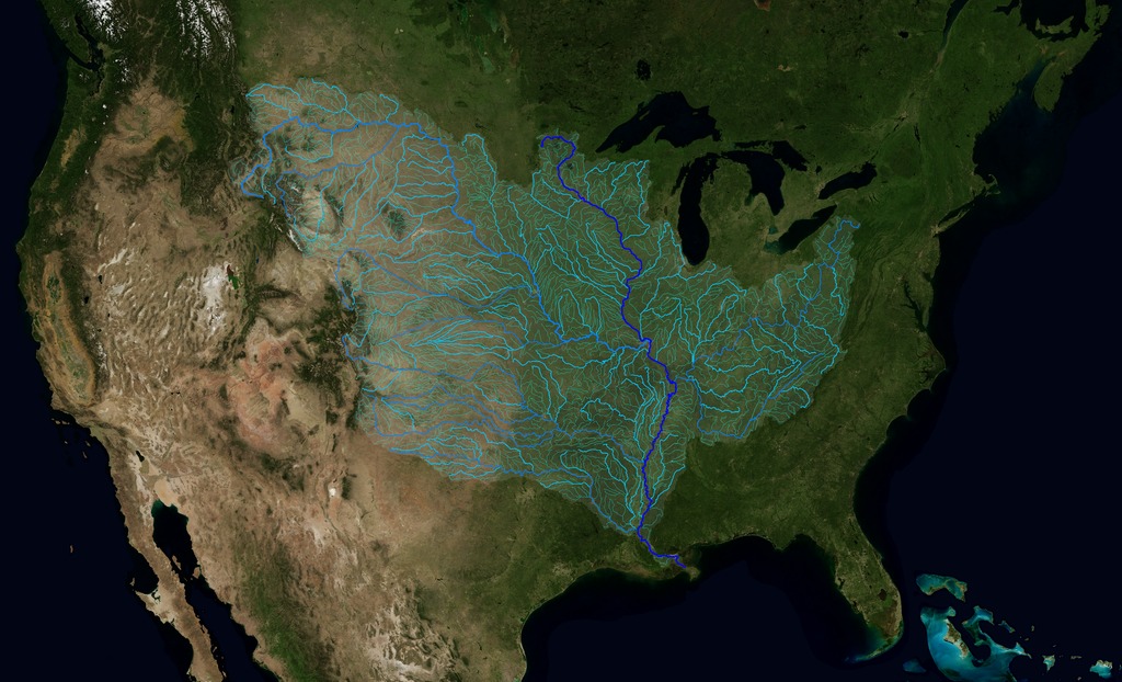
There are some 250 tributaries of the Mississippi which drain a total area of more than 1,247,000 square miles–one third of the nation’s landmass–extending from the Allegheny Mountains in the east to the Rocky Mountains in the west!

We start here with quick facts on the Mississippi River and several navigable tributaries! Please follow links for a little more depth of historical interest and to see our collection of hand-painted maps!

The Mississippi River, from its source at Lake Itasca in Minnesota, to the Gulf of Mexico, is approximately 2,348 miles long. The combined reach of the Missouri-Mississippi Rivers is 3,741 miles–a length exceeded only by the Amazon and Nile rivers. The Mississippi River has shortened by several hundred miles since the days of Mark Twain. Even today it varies 30-50 miles each year.

The widest navigable part of the Mississippi is Lake Pepin, on the Upper Mississippi, where it is approximately 2 miles wide. The average current flows from 1.2 miles per hour nearer Lake Itasca, and about 3 mi per hour nearer New Orleans. Our historic Mississippi River Ribbon Map has been a best-selling Gift for many years.

Yes! The Mississippi River map can be ordered FRAMED and delivered to loved ones from Great River Arts as a uniquely treasured Father’s Day or Mother’s Day Gift!

“This is a beautiful map!! My whole life is on this map! My home town, the towns where my kids live, even New Orleans, my favorite place to vacation!”

TRIBUTARIES OF THE MISSISSIPPI River  … Watershed map
U.S. Geological Survey EROS Center


Remember the great Mississippi River Flood of 1993? It wasn’t just the Mississippi River flooding that wreaked havoc, it was that all those tributaries flooded as well! At one point, the volume of water flowing past St. Louis was eleven times the volume of Niagara Falls!! You may also want to check out our interactive map of which of the tributaries are at flood stage today! Click INTERACTIVE MAPS in the category list, right hand column, to see where the tributaries are at flood level TODAY!!

Lisa now offers her own custom ribbon map designs of both the OHIO RIVER and the Missouri River. Please click on any map image for more info on the map or the tributary. Or PHONE 888-255-7726 to order any map. Click on map images for more info on the tributaries.

192 Missouri River Ribbon Map
017 Arkansa Territory 1827
The Arkansas River forms in the Rocky Mountains in Colorado and meanders 1,450 miles through Kansas, Oklahoma, and Arkansas.  It is the main water source for the state of Arkansas.Click here to see
more Arkansas River facts and Artisan Maps by Lisa Midd

/

Ohio River Ribbon Map

The Ohio River is the second major tributary of the Mississippi. It is formed in Pittsburgh by the junction of the Allegheny and Monongahela River and travels about 980 miles to Cairo, Illinois, and the Mississippi River. Interestingly, today’s Ohio River Basin is approximately the northern extremity of the ancient shallow sea that is represented today by the Gulf of Mexico! Consider that nearly 1/3 of the nation’s water drains past the confluence of the Ohio and Mississippi rivers at Fort Defiance in Cairo, Illinois!  

Click here to see more Ohio River facts and Artisan Maps by Lisa Middleton

The Illinois River

Illinois River Ribbon Map

The Illinois River, cutting through steep rocky bluffs, runs approximately 273 miles (439 km), with some 60 miles of scenic water. It flows through the heart of the State of Illinois, and links the great rivers of the American West with the Great Lakes, the St. Lawrence Seaway, and finally the Atlantic Ocean.

Historically, the Illinois River has had a significant impact on the state’s economy, communities, and peoples. Long before Europeans discovered America, indigenous tribes inhabited the Illinois River Valley and settled on the riverbanks, creating a river culture of their own. In 1673, Father Jacques Marquette and Louis Joliet surveyed the region, canoeing up to the Illinois River via the Mississippi River, hoping to find a route linking the Great Lakes to the Illinois River and the Gulf of Mexico. Today, the Illinois and Michigan Canals are the evidence that their vision became reality.

And for fun, checkout our fascinating 1841 STEAMBOAT MAP OF ILLINOIS
lists all the steamboat stops and distances along the Illinois River and the Mississippi, Ohio and Vermillion Rivers!

Wonderful detail!

119 1841 Steamboat Map of Illinois

Planning for an upcoming CRUISE? We’ve featured several of our SMALL BOAT CRUISE destinations here!
WATERWAY CRUISE REPORTS

Rain and More Rain!

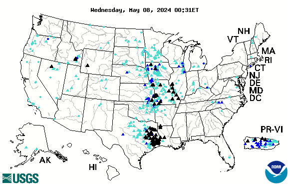
Much of the central part of the country, along with the Lower Mississippi, is currently experiencing dangerous high water. See up to the minute status reports for American rivers by clicking on our INTERACTIVE FLOOD MAP. Black triangles indicate serious flooding.

Related categories are highlighted above this story. Click on a category above to see more stories from our massive archive!

This map is interactive and constantly updated by the USGS.

us

Looking for more great content, lots of river content available by clicking on any of the category links shown below the comments!

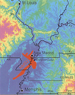
USGS Reports Earthquake Swarms in Missouri

      Is the big one about to hit the central United States? Maybe not, but a recent swarm of medium-sized earthquakes in Missouri’s New Madrid region has residents on edge.        nmblog_NewMadrid

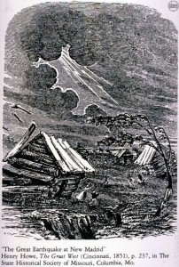
 The area of the New Madrid fault is the site of the nation’s most powerful earthquakes ever east of the Rocky Mountains which occurred in 1811–12 and caused the Mississippi River to flow backwards. This same area experienced six quakes on Monday, September 30, 2019, according to officials with the United States Geological Survey.


Two larger quakes were originally reported as 2.8 in magnitude each. They were later each downgraded to 2.7 magnitude. The third large quake was originally reported as a 2.7 magnitude. It was later downgraded to a 2.6 magnitude.  A sixth was recorded later in the day.

All six recorded earthquakes on Sept 30, 2019 include:

According to the USGS, there have been 12 earthquakes in the past seven days in the Heartland. Click on the blue links for detailed info from the USGS.

New Madrid If an earthquake the size of the 1811-12 earthquake hit today, cities from St. Lto Memphis would see extensive damage in the hundreds of Billions with a loss of possibly thousands of lives. Midwestern cities typically do not have building codes that account for earthquakes because of their relatively rare occurrence.

–Dwight Widaman, Metrovoicenews.com 


New Kindle Versions of our Most Popular Steamboat Book…and a Little Something Extra!

If your favorite River Buff has become a Kindle fan, we now have the following NEW Kindle Editions available for Pre-order for Christmas gifting this year!

6CCFCF9F-6FBC-4B3C-8BB3-C2D3CF34E3B1
“Treasure Hunting” has been one of our most requested river topics through the years. Pirates, military trails, payroll caches, old maps and steamboat wrecks have all left tales of sudden death and unrecovered treasures. In the first of our Kindle “INSIGHT Series” we  have collected a number of our previously published favorite treasure hunting stories, how-tos, and resources available to the Treasure Prospector here on the upper Mississippi River.

One Man’s Treasure” is now available for pre-order in the Kindle Store. PRE-ORDER RIGHT HERE, now, just $2.99!

bright Come Hell Cover VOL 1 Kindle
Our ever-popular steamboat anthology, COME HELL OR HIGH WATER by Michael Gillespie is newly available as a quality 2-Volume KINDLE edition. Filled with historic photos, witty commentary, footnotes, bibliography, Glossary and fascinating river facts and stories. Each Volume is purchased separately. 

Volume 1 PRE-ORDER RIGHT HERE.   $9.95

 Volume 2 PRE-ORDER RIGHT HERE.  $9.95


Midwestern Flooding

Much of the central part of the country is currently experiencing dangerous flash floods. See up to the minute status reports for American rivers by clicking on our INTERACTIVE FLOOD LINK in the category list to the right.

us

Looking for more great content, lots of river content available by clicking on any of the category links.