
 I recently ran across a number of stats presented by area scientists regarding the massive rains along the Upper Mississippi River last August. These rains produced unprecedented landslides in bluff country that resulted in seven deaths and several homes on both sides of the river sliding down onto the roads.
For more detailed stories, stats, photos, and reports from the August 07 flooding and landslides, see http://www.greatriver.com/natural/disaster/August07.htm
Official FLOOD STATS
15.1 inches of rain fell in Hokah, Minn., over a 24 hour period on August 19. The previous high was 10.84 inches set in 1972.
The Root River crested at 18 feet in Houston, Minn. When compared with previous flooding events, the August ’07 floods had up to 5 times more rainfall.
Scientists report that the flood was so rare, the probability of its existence was once in 500 years, perhaps even once in 1,000 years. The storm’s wrath was comparable to a Category 5 hurricane.
Interestingly enough, the invertebrate count in large streams fell from about 4,000 per square meter to just 1000 after the flood. A specific amphipod, a staple of trout diets, dropped from about 250 per square meter to less than 10.
23.6 inches fell during the month of August, 9.5 inches shy of the average ANNUAL precipitation.
For more on the dangers posed by landslides on the 600 ft high bluffs along the Minnesota and Wisconsin border see our feature from Fountain City, Wis., When Bluffs Throw Boulders. On April 5, 1901 a single boulder fell from the bluff face to smash a home and kill its occupant. Some 85 years later it happened again… in the same spot. This time, the Rock was left in place and is open to the public for viewing at the Rock in the House attraction on Hwy 35.
GEOLOGY 101… WHY Land Slides Happen along the Mississippi River Bluffs
 The bluffs of the “Driftless” region that stretches along the Mississippi River are formed of limestone bedrock covered by an ancient mix of clay and river silt. Under most conditions this is provides a solid base for home building, though most counties restrict building to a slope of 20-30%. Homes that are built on “benches” may have much steeper areas above them (or below). Between 1998 and 2006, 205 homes and 10 condominiums were built in La Crosse County on slopes with between 20% and 30% slopes.
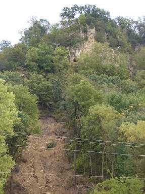
Historically heavy rain during the night of August 19, 2007, meant that water drained from the tops of the bluff to flow into the valleys. Water flowing over the rock faces probably fell like fabulous waterfalls (though I haven’t run across anyone who can claim to have seen it). This completely saturated the clay and silt which cover the bluffs.
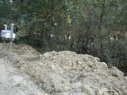
According to a La Crosse Tribune story, as water particles fill the space between silt particles the silt and clay firstbecome “plastic” and then “viscous.” When “plastic” it will move when pressure is applied to it (such as the weight of a home). When “viscous” it begins to flow under its own weight… like a glacier, only much more quickly. This flow is what caused the collapse that is so visible in the bare canyons, and the mud and rubble along the base of the bluffs throughout the coulee region.
The soils may have been more vulnerable because the area was so dry, and the water fall so far beyond the historic record. The fact that residents remove the thick canopy of deep rooted trees and brush to plant grass may also have made the bluff sides more vulnerable, according to La Crosse County.
Aftermath?
Certainly many counties will be reconsidering restrictions on developing bluff side slopes. Onalaska currently restricts building on slopes of more than 20%, Holmen restricts building on slopes over 12%, La Crosse 30%, town of Bergen restricts development at 20% but does allow building on “benches.” Winona currently restricts building on slopes greater than 15%.
Many researchers point to increasingly severe droughts, rain and heat as the by-product of global warming. So can we expect more such rains? The experts do think so.
More!
Chronology of the Rains in August 2007
When Boulders Roll … Landslides on the River
Return to the Mississippi River Home Page at www.greatriver.com