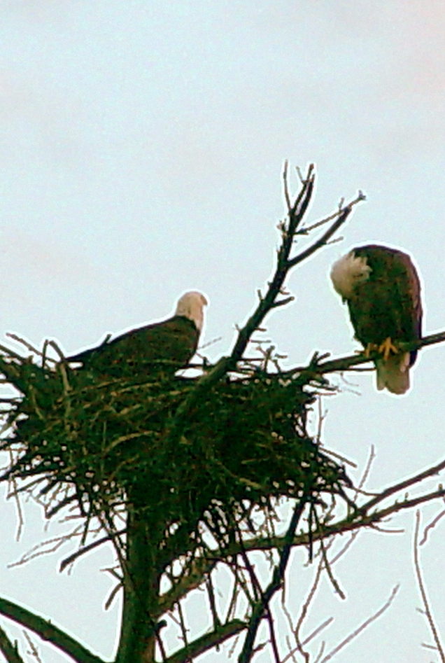
I will begin posting 2021 Bald Eagle Watching events in the Upper Midwest as I learn of them. The events celebrate the opportunity we have had to observe the comeback of American Bald Eagles from the endangered species list. According to the DNR, bald eagle populations in Wisconsin have grown from 108 occupied nests in 1973 to almost 1,700 in 2019.
To read more about the evolution of public Bald Eagle Watches which first began in Keokuk, Iowa, enter the key words “Bald Eagle” in the SEARCH box at the top of this page. Articles include eagle watching advisories, where, when and how to participate, and a general annual schedule of when/where events are held. Our first event:
SAUK PRAIRIE — Sauk Prairie area’s Bald Eagle Watching Days, Wisconsin’s longest-running bald eagle watching event, will be held virtually this year due to COVID-19.
“Our planned virtual programming will feature the release of a rehabilitated bald eagle to the wild, a live raptor show and many more of your favorite events and presentations,” said President of the Ferry Bluff Eagle Council Jeb Barzen. “We’ll provide experts to answer your questions and show eagle watchers how they can safely visit the area and see the birds themselves using our new self-guided tour.”
Programming will be a mix of live streams and pre-recorded videos beginning at 1 p.m. on Jan. 16 and 23 and Feb. 6 and 20. Links and program scheduling can be found here.
If you’d still like to see the eagles in the wild, you can visit the Sauk Prairie area in Jan. and Feb. for a self-guided tour using a mobile device. More information can be found here.
A Recollection of the Christmas Holiday in Frontier Green Bay Army Colonel John Mc Neil. by Albert G. Ellis (possibly early 1820s)
The Colonel, an Eastern Yankee, learned that French people at the Bay celebrated Christmas as a high festival, so he decided to help his men and the citizenry honor the day in these “ends of the earth.”
He sent formal invitations for dinner and a ball to everyone. Food was prepared for 100 guests and on Christmas Day a big hall at the Fort was filled with French, Indians, and Americans sharing holiday greetings.
Army Colonel John Mc Neil
Clothing ran from the latest Parisian styles to buckskin coats, pants, petticoats, and moccasins.
None of the elite considered himself over-dressed nor none of the citizens reproached himself with the least want of etiquette, or disrespect to their host, on account of costume or manner.
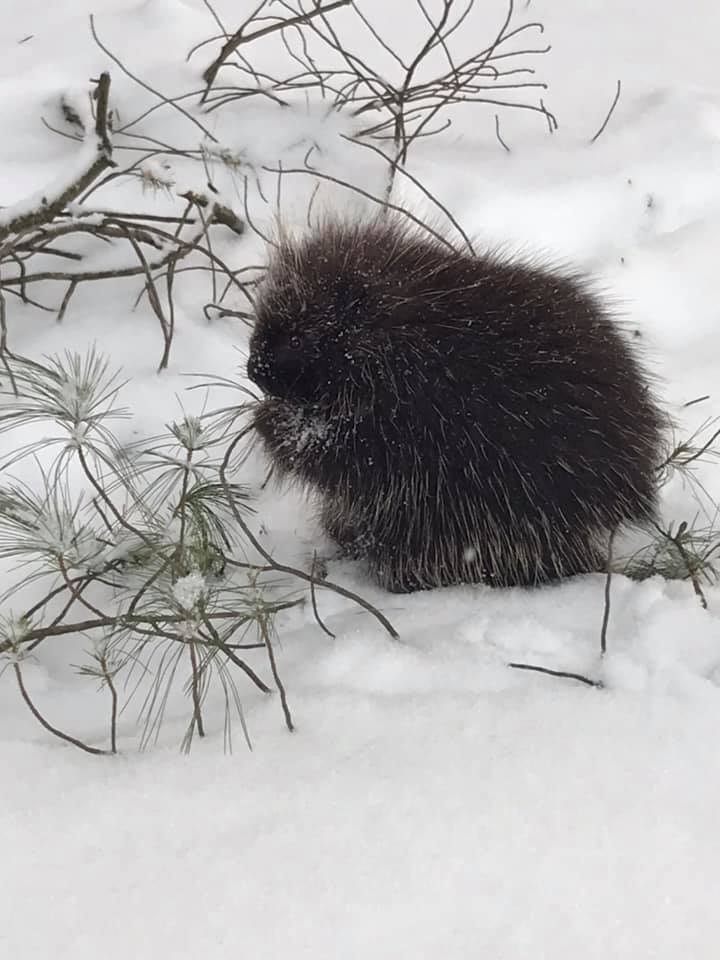
The dinner equaled one expected in a more civilized setting in quantity, if not in kind. Venison, bear meat, porcupine, geese, ducks, and many fish headed by the sturgeon, were offered for the main course. Dinner, dancing, and revelry latest throughout the Christmas night.
(I enjoyed discovering these two brief excerpts from the lives of Wisconsin explorers found in an anthology of essays adapted from WISCONSIN CHRISTMAS, edited by Terry R. Engels. And since porcupines are mentioned twice, I include a picture from this Winter in NW Wisconsin! Thank you, Laurie! ~ Pat)
La Fete de Noel, by Father Paul LeJeunne, 1665
“The Lord gave us for our Christmas supper a porcupine large as a suckling pig, also a rabbit. It was not much for eighteen persons, but the Holy Family were not so well treated on this very day in Bethlehem.”
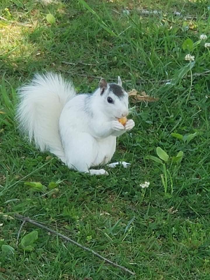
Merry Christmas everyone! I enjoy sharing images I run across of some of nature’s more beautiful creatures… the nearly white leucistic (leucitic) creatures that live in our forests and yards. Use the key words “white phase” of leucistic in the search box above to see more images.
The Grizzly Bear below has a story I can share. It was photographed by a family driving near Banff National Park, Alberta on the Trans-Canada Highway. Park staff have been monitoring the white grizzly and its sibling since 2017.
White Grizzly Bear Spotted in Banff, Alberta
The Clarkson family actually spotted two grizzly bears searching for food on the highway. One of them was ordinary while the other one was pure white. Cara claims that they are very “lucky because white grizzly bears are unheard of.”
A local bear expert and ecologist, Sarah Elmeligi, agrees with Mike’s statement and claims that the result of the bear’s color is recessive genes.
Monitoring the White Grizzly
Banff National Park staff have been monitoring the white grizzly and its sibling since 2017. At the time, the white grizzly left its mother and the staff named it Nakoda. The meaning of its name is ‘ally’ or ‘friend’ in the language of the native people of Stoney Nakoda Nation.
Dec 24, 2020. Merry Christmas everyone. Some may be surprised I still have Tundra Swans, pictured in the header. In fact, during the Christmas Bird Count on Dec 19, our La Crosse Audubon group reported counting 2600 Tundra Swans (big movement over the area), and a high number of duck species despite still water areas being frozen. So yes, you may still be seeing Tundra Swans passing through.
(Nov 2020) Now that our Tri-State bluffs are clad mostly in the deep browns of persistent oak foliage, and the first measurable snow has sprinkled down, we are seeing the Tundra swans winging their way into Pool 8 once again! It’s always one of my favorite birding seasons. As is normal, we not only have elegant Tundra swans resting and feeding, but large “mobs” of American white pelicans are gathering. Migrating ducks also form vast rafts…puddle ducks in more sheltered areas; diving ducks in open water upriver of the locks and dams. Check out the rest area near Brownsville, MN, and the open water south of Goose Island in Wisconsin. The highway pulloffs allow parking and offer scopes and often volunteers to help explain why the swans stop in Pool 8 and what other migrating waterfowl might be identifiable. Eagles are frequent and will become even more so in November!!
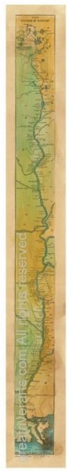
Fine Art River Print. Hand- painted by Lisa Middleton. Available from Greatriverarts.com
Woah, driving the Mississippi River for the past few days, and WOW, has the color popped! It seemed sudden and early to me, based on past years when riding the steamboats and the bluffs would pop as late as October 15! But we found color from Madison to Northern Wisconsin already.
Try this new 2020 Fall Color Prediction Map for the entire US! It says Smoky Mountains, but it is actually the whole country!
Treasure Hunting is a perfect outdoor activity for cool and colorful days. Our beginner’s guide to Treasure Hunting along the Mississippi River is a favorite among our readers! Available now from AMAZON Books for just $2.99.
Fall Foliage Hot Lines from greatriver.com While mid-October seems to be the time when Fall Foliage really POPS along the Upper Mississippi River, we on the Upper River are certainly already seeing brilliant red sumacs. Softwoods are starting to yellow up. You can follow the southward march of Fall Color with the contacts below. Weather is perfect, enjoy the drive!
And don’t leave home without the indispensable guides to Mississippi River and Great River Road travel! Every volume of DISCOVER! America’s Great River Road is filled with a variety of fascinating Mississippi River fact and lore. Photos, maps, charts! All Volumes contain info on birding, wildlife viewing hotspots. Each highlights Geography, interpretive history and natural history attractions along the Great River Road.SAVE $10!!!
Click HERE to PurchaseDiscover! America’s Great River Road… St. Paul, Minnesota, Discovr! Guides are available in four volumes from St. Paul to Venice, Louisiana, individually signed by the author. Available on Amazon as paperback ($22) or KINDLE guide (9.99). Or phone 888-255-7726 and we will send you your copy TODAY.
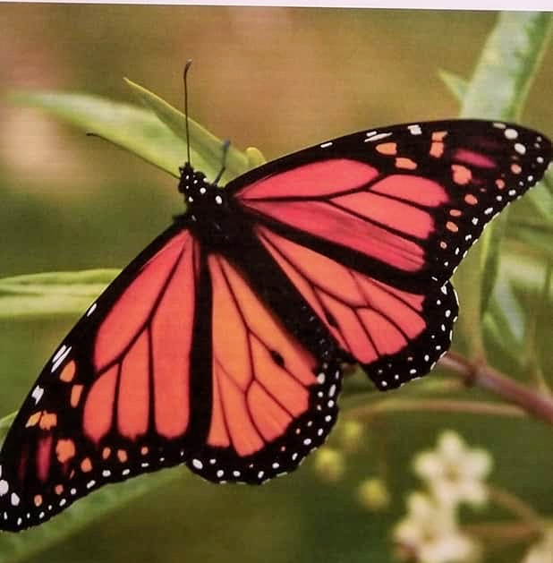
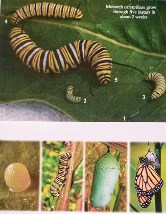
We have been watching our local Monarch butterflies since early August, fluttering around our wetland Milkweed and Joe Pye weeds.
With the grand-kids, we have been able to observe the singular egg, the distinctive caterpillars who ate the leaves voraciously…like lawn mowers… the delicate chrysalis, and finally, the magical moments of transformation to an adult butterfly!
Please enter Monarch in the Search Box in the upper right to see more on Migrating Monarchs from GreatRiver.com
Boaters in September will find them frequenting the Mississippi River on their meandering, multi-generational migration to Mexico and back.
Yes! Great River Arts offers quality note cards, Prints, and Map art for a variety of Butterfly Species. Find beautiful hand-painted map art and quality prints of Mexico and the Caribbean! Visit greatriverarts.com
The story of Iowa’s five Sullivan brothers is one I have been meaning to share for a long time! I was contacted by family members when I did the last update to Volume 2 of DISCOVER! America’s Great River Road. The Sullivan Brothers Iowa Veterans Museum in Waterloo, Iowa, has since taken it on as a way to celebrate ALL Iowa Veterans.
Looking for a great historic get-away? This might be a meaningful destination for you!
Waterloo’s five Sullivan Brothers gained national attention when they enlisted in the Navy after the attack on Pearl Harbor and insisted they be allowed to “stick together” while in the service. After initially refusing, the Navy granted their request. All five brothers were lost when their ship, the USS Juneau, was torpedoed on November 13, 1942, following the Battle of Guadalcanal. This sacrifice remains the largest single loss for a family in American military history.
“As Commander-in-Chief, I want you to know that the entire nation shares your sorrow … I am sure that we all take heart in the knowledge that they fought side by side. As one of your sons wrote, ‘We will make a team together that can’t be beat.’ It is this spirit which in the end must triumph.” — President Franklin D. Roosevelt to Thomas and Aleta Sullivan, January 13, 1943
The Sullivan Brothers Iowa Veterans Museum honors the service and sacrifice of all Iowa veterans from the Civil War to present. Step into their stories through traditional exhibits, interactive activities and an electronic Wall of Honor. The Museum consists of over 35 interactive exhibits. Interviews collected via the Voices of Iowa Oral History Project total over 1,500
The Story of the Sullivan Brothers and Their Impact on Navy Policy…
The Sullivans enlisted in the US Navy on January 3, 1942, with the stipulation that they serve together. The Navy had a policy of separating siblings, but this was not strictly enforced. George and Frank had served in the Navy before, but their brothers had not. All five were assigned to the light cruiserUSS Juneau. (all links provided by Wickipedia).
Early in the morning of November 13, 1942, during the Naval Battle of Guadalcanal, the Juneau was struck by a Japanese torpedo and forced to withdraw. Later that day, as it was leaving the Solomon Islands’ area for the Allied rear-area base at Espiritu Santo with other surviving US warships from battle, the Juneau was struck again, this time by a torpedo from Japanese submarine I-26. The torpedo likely hit the thinly armored light cruiser at or near the ammunition magazines and the ship exploded and quickly sank.
Captain Gilbert C. Hoover, commanding officer of the light cruiser USS Helena and senior officer present in the battle-damaged US task force, was skeptical that anyone had survived the sinking of the Juneau and believed it would be reckless to look for survivors, thereby exposing his wounded ships to a still-lurking Japanese submarine. Therefore, he ordered his ships to continue on towards Espiritu Santo. Helena signaled a nearby US B-17 bomber on patrol to notify Allied headquarters to send aircraft or ships to search for survivors.
But in fact, approximately 100 of Juneau‘s crew had survived the torpedo attack and the sinking of their ship and were left in the water. The B-17 bomber crew, under orders not to break radio silence, did not pass the message about searching for survivors to their headquarters until they had landed several hours later. The crew’s report of the location of possible survivors was mixed in with other pending paperwork actions and went unnoticed for several days. It was not until days later that headquarters staff realized that a search had never been mounted and belatedly ordered aircraft to begin searching the area. In the meantime, Juneau’s survivors, many of whom were seriously wounded, were exposed to the elements, hunger, thirst, and repeated shark attacks.
Eight days after the sinking, ten survivors were found by a PBY Catalina search aircraft and retrieved from the water. The survivors reported that Frank, Joe and Matt died instantly, Al drowned the next day, and George survived for four or five days,[1] before suffering from delirium as a result of hypernatremia (though some sources describe him being “driven insane with grief” at the loss of his brothers); he went over the side of the raft he occupied. He was never seen or heard from again.
Security required that the Navy not reveal the loss of Juneau or the other ships so as not to provide information to the enemy. Letters from the Sullivan sons stopped arriving at the home and the parents grew worried, which prompted Alleta Sullivan to write to the Bureau of Naval Personnel in January 1943, citing rumors that survivors of the task force claimed that all five brothers were killed in action.[2]
This letter was answered by President Franklin D. Roosevelt on January 13, 1943, who acknowledged that the Sullivans were missing in action, but by then the parents were already informed of their fate, having learned of their deaths on January 12.[2] That morning, the boys’ father, Tom, was preparing for work when three men in uniform – a lieutenant commander, a doctor and a chief petty officer – approached his door. “I have some news for you about your boys,” the naval officer said. “Which one?” asked Tom. “I’m sorry,” the officer replied. “All five.”[3]
The brothers left a sister, Genevieve (1917–1975). Al was survived by his wife Katherine Mary and son Jimmy. Joe left a fiancée named Margaret Jaros, while Matt left behind a fiancée named Beatrice Imperato.[1] The “Fighting Sullivan Brothers” became national heroes. President Roosevelt sent a letter of condolence to their parents. Pope Pius XII sent a silver religious medal and rosary with his message of regret. The Iowa Senate and House adopted a formal resolution of tribute to the Sullivan brothers.
Tom and Alleta Sullivan made speaking appearances at war plants and shipyards on behalf of the war effort.[4] Later, Alleta participated in the launching of a destroyerUSS The Sullivans, named after her sons.[5]
On Saturday, March 17, 2018 the wreckage of the USS Juneau was discovered by Microsoft co-founder Paul Allen off the coast of the Solomon Islands.[6]
As a direct result of the Sullivans’ deaths (and the deaths of four of the Borgstrom brothers within a few months of each other two years later), the U.S. War Department adopted the Sole Survivor Policy.[7]
A museum wing has been built in honor of their service in World War II. The museum is located in downtown Waterloo, Iowa, their hometown. It was completed in 2008. The grand opening occurred on November 15, 2008. The $11.5 million, state-of-the-art facility aims to play a role in preserving the history and service of Iowa veterans and serve as a facility for research and genealogy studies.[8]
The Navy named two destroyersThe Sullivans to honor the brothers: The Sullivans (DD-537) and The Sullivans (DDG-68). DD-537 was the first American Navy ship ever named after more than one person. The motto for both ships was/is “We stick together.”[9]
Al Sullivan’s son served on board the first USS The Sullivans. His grandmother christened the first ship. The second USS The Sullivans was christened by Al’s granddaughter Kelly Ann Sullivan Loughren.[10]
Thomas and Alleta Sullivan toured the country promoting war bonds and asked that none of their sons died in vain.[11]
Genevieve, their only sister, served in the WAVES. She was the girlfriend of Bill Ball, whose death at Pearl Harbor prompted her brothers to join the Navy to avenge him.[12]
The brothers’ story was filmed as the 1944 movie The Sullivans (later renamed The Fighting Sullivans) and inspired, at least in part, the 1998 film Saving Private Ryan.[13] The Sullivans were also briefly mentioned in Saving Private Ryan.
The brothers’ hometown of Waterloo, Iowa, renamed its convention center in 1988 as “The Five Sullivan Brothers Convention Center”. In June 2017, the city was considering a proposal to sell the center to a developer who would renovate the facility and change its name. The proposal met with some community opposition.[14] The town also named a street and a public park in their honor. The park is the location of their childhood home.[15]
The Sullivans were not the only brother sailors on board the ship. There were at least thirty sets of brothers, including the four Rogers brothers from New Haven, Connecticut. Before the ill-fated Savo Island operation, two of the Rogers brothers were transferred to other commands. According to those who survived, had the ship returned to port safely, at least two Sullivans would have also transferred.[1]
The Sullivans Association, an organization of veterans who served on both US Navy ships named after the brothers, conducted a reunion on September 25, 2011, in Waterloo, Iowa. The attendees gathered at Sullivans Park, visited Calvary Cemetery and laid flowers at the graves of the Sullivan brothers’ parents and sister, and visited the neighborhood where the family had lived.[18]
Sunny days, green bluffs and sparkling Mississippi River remind us that fun and socially responsible activities are all around us…and not limited just to our beautiful parks!! The Great River Road offers easily accessible scenic overlooks, fishing spots, historic side routes to tiny towns with big stories to share, and a fabulous opportunities for watching large wildlife. Eagles, Sandhill Cranes, Egrets, herons, pelicans, and Trumpeter swans are not hard to spot on a day’s drive. Take a picnic lunch and a copy of the nearest Volume of DISCOVER! AMERICA’s GREAT RIVER ROAD and make each day memorable!!
Check out all our Mississippi River products online at www.greatriverarts.com Are you a Kindle reader? Yes! Books are also available online at Amazon’s Kindle books and in regional gift shops along the river.
at Middleton and Great River Publishing have provided fascinating detail on life along the Mississippi River since 1987! TheMississippi River Activity Guide for Kids will provide summer structure for the elementary aged kids. In Volumes 1 (Upper), 2 (Middle), 3 Lower, 4 (Delta) of Discover! America’s Great River Road, Pat becomes your “friend on the road” providing in-depth background on everything you see along the Mississippi River. Father’s Day is a great time to gift your Dad a fascinating regional book or an historic map he will REALLY LOVE. Check out all our Mississippi River products online at www.greatriverarts.com
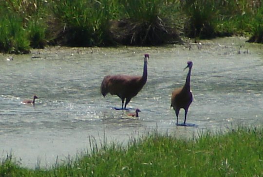
One of my all time favorite snapshots of the Sandhill Cranes with chicks in 2009. While the chicks (colts) are still quite small, the adults take them strolling through meadow, marsh, and even the pond.
Chick in Front, Dad in shade
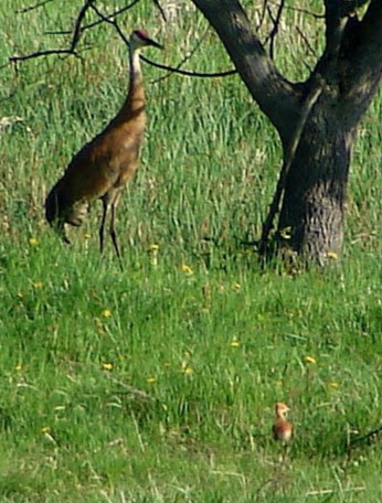
May 6, 2020 and our single chick was hatched right on time, in the same locale as the parents have nested for the past 14 years. This year, I noted how very quiet and secretive they were around the nest. The second adult was alway on guard, well away from the nest, quite visible, but always on task. I think having an Eagle in the neighborhood has taught them to be far more cautious than they were in the first ten years!!
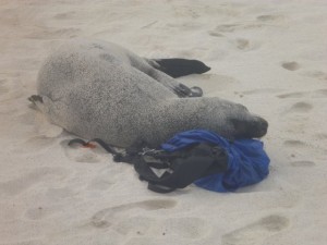
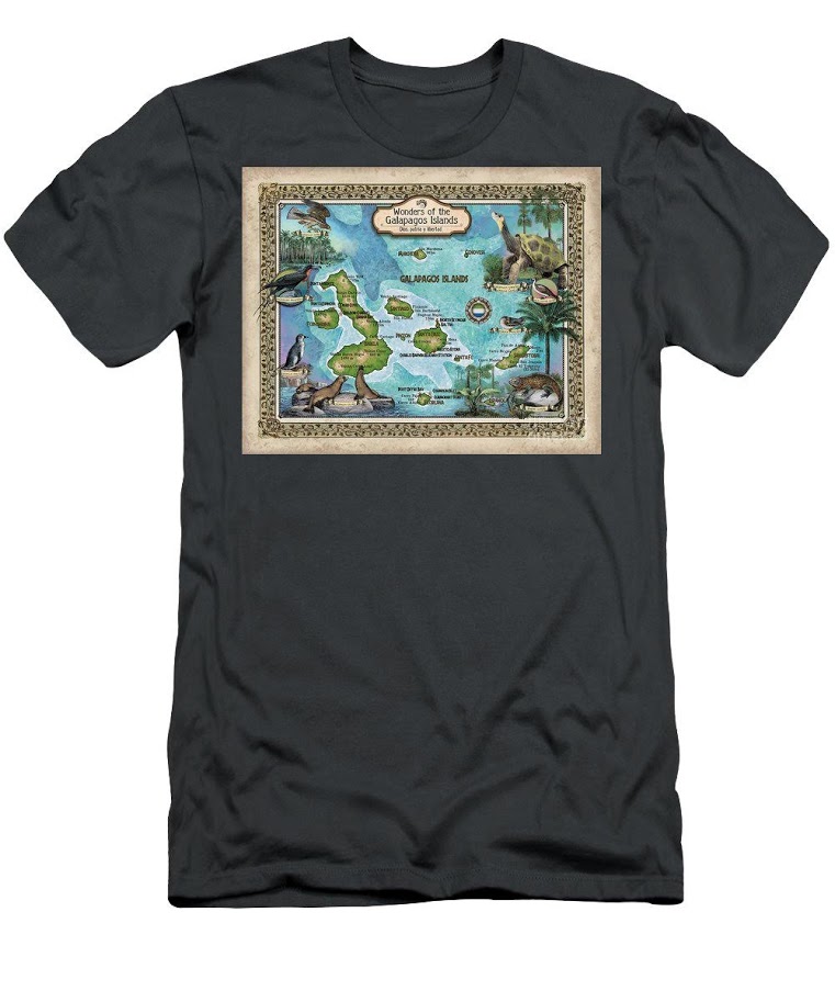
The Galapagos Island cruise reports are among our most popular Waterway Cruise Reports...
“The best part of traveling the Galapagos is an amazing up close and persoal experience with the wildlife who call it home. This seal really loved my backpack!“
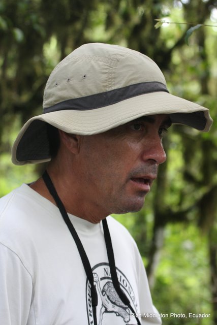
Alex was our preferred naturalist… mainly because of his love of the islands, and because of his 20 years of experience! But for those whose personal perspective is that this was a “vacation” and no “mandatory learning” was allowed, we had a second naturalist whose main focus was “learn a little” and have a great time! Every Galapagos naturalist today is professionally trained to interpret and protect this unique natural heritage.
On my first open ocean snorkeling excursion, I panicked and clung to the ladder.
“Alex,” I urged, “don’t wait for me. I’ll just hang here for a while.”
“I don’t go anywhere unless you decide to come with me, or get back in the boat,” he explained. “I don’t leave you in the water alone.” I felt absolutely safe with Alex from that point forward.
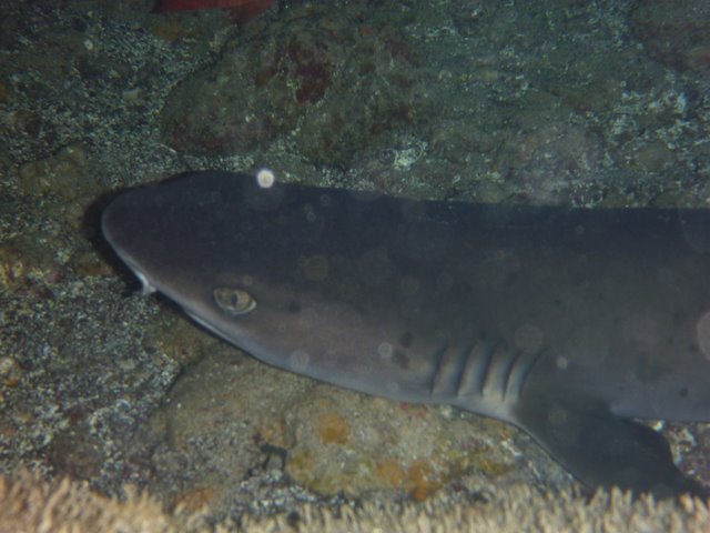
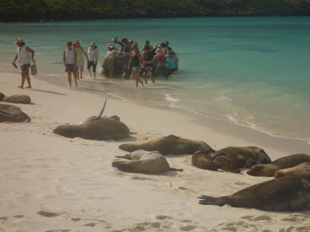
Snorkeling, panga rides, and kayaking were all available options for daily water-based activities. Snorkeling was by far the most popular… Turtles, white-tipped sharks, swimming with sea lions, and even “circling-up” when visited by several hammerhead sharks provided highlites on our Galapagos cruise. Oh yes, and we were joined by a pod of leaping dolphins during one of many memorable panga excursions!
“I really could not believe it was ME out there snorkeling with Hammerhead sharks!” one Minnesota passenger exalted. And sea turtles were ABUNDANT in the clear waters!
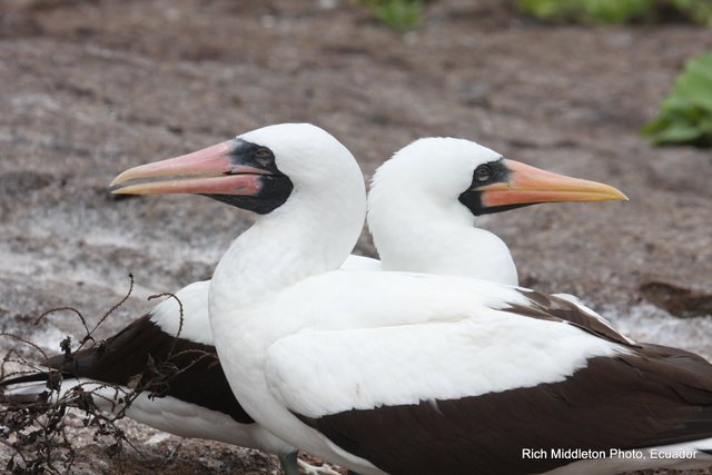
Twice each day, the naturalists led us ashore for an island hike. An afternoon nap was mandatory, so that everyone had the energy to do the really important stuff… like hiking among the booby’s and iguanas, and magnificent Frigate Birds.
The AMAZING thing is that these creatures truly have no fear of humans!! It was as if we had entered into the Garden of Eden.
While it is not necessary to be a student athlete to visit the Galapagos Islands, for the first time on any cruise, we found ourselves to be among the older visitors, rather than the younger!
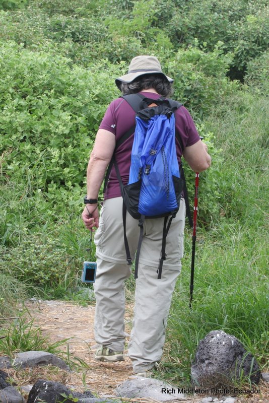
It IS necessary to be able to hike for a mile or two… some of it over rocky lava surfaces, or up and down short steep slopes.
“Wet landings” are common, so be prepared to swing your legs over the side of a rubber panga and in the gentle surf!
I did bring two pieces of “gear” that I found incredibly useful…trekking poles that could be unscrewed to fit in a small carry-on suitcase, and lightweight Salomon’s “Amphibian” style hiking shoes with webbing. The trekking poles worked great when we were on lava rocks.
The specialized water/hiking shoes were great for wet landings. The webbing meant shoes dried quickly. The hiking soles stuck like glue to wet rock and afforded comfortable cushioning for the rest of the hike.
Casual dress is definitely the order of the day for this cruise!