Save 40% until APRIL 26! Great Gifts for Mom, Dad, Siblings, Friends!

Save 40% UNTIL APRIL 26 on any of TWO of our $19.95 books at GREAT RIVER ARTS! Order on line and use the Discount Code FOLKS at checkout. (No other discounts apply) Order to 888-255-7726. Or Phone your Order to 888-255-7726.Steam Railroad 2 book gift set by Michael Gillespie

 “Mike’s Railroading books are for people who love to immerse themselves in the days of Steam. They are colorfully written, well-edited and take one through a gamut of emotions. You will read them more than once!”   ~ Purchaser comment


This is a great opportunity also to Purchase all FOUR of our DISCOVER! AMERICA’s Great River Road series and SAVE 40% over the regular individual pricing! 1000+ pages of fascinating information about the Heritage and Natural History of the Mississippi River. A first class collection for Traveler and resident alike by River Author, Pat Middleton. Order on line at Great River Arts and use the discount code FOLKS or phone 888-255-7726 to order by April 26!  We have never made an offer like this!  Save more than $30! 

Limited time offer: One Man's Treasure- Featuring Discover! America's Great River Road $1 Ebook Sampler! 


 Lisa New Logo

Larger format FINE ART Prints (18×20 and larger) of ALL Lisa Middleton Maps are available for 40% off at greatriverarts.com when you use the code FOLKS, at checkout. PicMonkey Collage murals

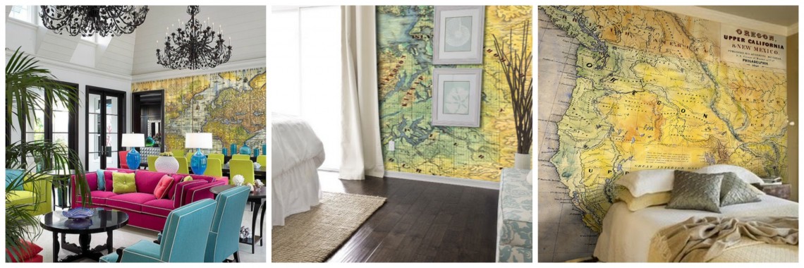
This is an amazing opportunity for those who prefer a larger format of any map from Great River Arts. Only until April 26!! Check this out today! Or call 888-255-7726 to ask about having a CUSTOM MAP designed!


SPECIAL MAP OFFER for our river buffs:  Purchase 2 of our newest custom designed maps and save 40%.  Get BOTH MAPS for just $35.  This is a special $62.50 value from Great River Publishing! Available by phone only.   888-255-7726DRIFTLESS AREA

215 The Ice Age Trail Map, Wisconsin Designed by Lisa Middleton


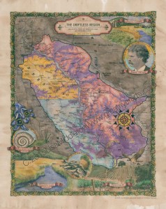
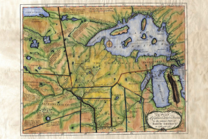
The  DRIFTLESS Region map (above) captures portions of Minnesota, Iowa, Wisconsin and Illinois anchored by the Mississippi River.

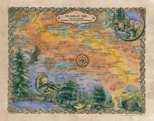
Its corollary is the ICE AGE TRAIL that follows the moraines of the last Ice Age from Door Count, Wisconsin, to the St. Croix River and Minnesota border.

Perfect for Dad, a brother or other MAP buff in your family! Or keep one for yourself! Each map includes extensive historical and geologic notes.


How Fun is This? Cruising on the River Steamer, African Queen

African Queen Key Largo

How fun is this? The actual little river steamer from the movie, AFRICAN QUEEN, with Katherine Hepburn and Humphrey Bogart is docked in Key Largo, Florida at Mile Marker #100.


I was able to take the helm and pilot it during most of our cruise, and the gentle put-put of the engine and its “naked” operation was a huge delight. The boat itself celebrated its 100th year in 2012. It has been fitted with an 1880s steam engine and is available for short sightseeing and Dinner cruises through the canals of Key Largo and out into the Key Largo Sound.  It only carries a maximum of 10 people, there were 4 of us on our little excursion!

The iconic vessel was made famous in the 1951 movie of the same name and she still remains a timeless classic. This famous steamboat is available for daily canal cruises and dinner cruises in the Port Largo Canal area and also for private events. 54BE53F1-6C83-4CF9-8163-95498905E7DA   
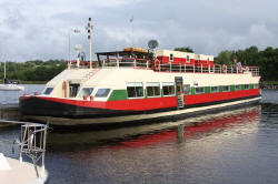
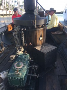
Engine and today’s diesel boiler.

A LITTLE HISTORY: The African Queen was built in Lytham, England in 1912 for service in Africa for the East Africa British Railways company. She was used to shuttle cargo, missionaries and hunting parties across the Victoria Nile and Lake Albert which was located on the border between the Belgian Congo and Uganda.

In 1951 she starred in the famous movie directed by John Huston. Afterwards she remained in service in Africa until 1968 when she was brought to the United States working in San Francisco, Oregon and Florida. She has been the pride and joy of  Key Largo since 1982, where she is registered as a National Historic site and in 2012 celebrated her centennial year.  Below is a video of the steam engine. It should be horizontal, not vertical!

It has been fitted with an 1880s steam engine and is available for short cruises through the canals of Key Largo and out into the Key Largo Sound.  Below left shows the steam engine and boiler (diesel). I also tried to insert a video of the engine operating.


CONTACT:  PHONE: 305.451.8080  Website: africanqueenflkeys.com  There is a lot of interesting info on the boat, the movie, and the history of its service in Africa!

 keywest

If the Florida Keys is one of your favorite places, check out our hand-painted historic and custom designed maps of Florida available for purchase or viewing by clicking HERE on our FLORIDA FINE ART MAP site!

Everyglades LR

Everyglades LR

Find the Everglades, all five coasts of Florida, and beautifully painted historic hand-painted historic and custom designed maps of Florida by clicking HERE on our FLORIDA FINE ART MAP site! 

Use the SEARCH BOX at Great River Arts to search ALL our extensive collection of Fine Art Maps from across the country and the world!! 

Tundra Swan Reflection

We are blessed to have a number of really wonderful wildlife photographers on the Upper Mississippi River. I’ve often mention Alan Stankevitz as a favorite. He has posted one of his beautiful Tundra Swan videos with his note and a link below. Alan often employs some of the more advanced photo technology, which makes his work really unique.  Enjoy!

From Alan:  This fall, I had the opportunity to spend some time down on Pool 8 of the Mississippi River to photograph and video the fall migration of waterfowl and of course, Tundra Swans.  You can find my journal entry with a few photos here.

It really is difficult to portray the beauty of the area however in just pictures and with that I have created a video showing not only the Tundra Swans but some beautiful sunrises and sunsets. This video is on Youtube and if by chance you have a 4k monitor or TV, you can view it in its 4k full resolution.   Click here to watch the video.

Enjoy and here’s to a Happy, Peaceful and Healthy New Year!

Great River Map Artist is in the news again!

Map Artist, Lisa Middleton, got her start on the Mississippi River, but she is truly nationally know for her custom designed artisan maps as well as her extensive body of hand painted historic maps. Her summer home is Montana, and the Northwestern market is keeping her busy. See ALL Lisa’s maps at www.greatriverarts.com

No automatic alt text available.

Exploring Lake Superior’s North Shore!

Enjoy exploring Lake Superior’s north shore through the eyes of our map artist and the early explorers! Thank you, Courtney for writing us! See maps at www.greatriverarts.com   Entire map title or region in a Search Box.

5 out of 5 stars
“I’m absolutely in love with these maps! My fiance and I purchased these to go along with pictures we took while visiting the boundary waters and these maps are the icing to the cake!”   Courtney

7A737DD6-4EB0-41D6-A52D-3772D8896675-324-0000002B5F586647

Boundary Waters, custom artisan design by Lisa Middleton

IMG_1587

Custom map by Lisa Middleton  A fun combination of past and present!

t!IMG_0923

Carver’s historic map of his travels includes so many historic notes… and the Grand Portage is carefully noted by extra large dots!

C6291F21-62BE-40C8-9288-FB6A822FA35D-324-0000002B638C4759

The Gunflint Trail includes lots of local landmarks which will have you remincing about when you went where and with who!

Lisa’s maps are available all along the Gunflint Trail and at many better gift shops along Hwy 61… or visit www.greatriverarts.com and search for Lake Superior maps!  Have fun!


Current Interactive Flood Map

Below is the USGS interactive map that provides REAL TIME info on which Rivers in the US are cresting. The map below is accurate every day. Black Triangles indicate flood stage. Looking to compare stats with the Flood of 1993? CLICK HERE.

us

See more interactive maps by clicking the category in the list to right: INTERACTIVE MAPS

Saving the Delta Queen…. Saga Continues!

Hot off the Press! The Delta Queen hasn’t been written off yet!

WASHINGTON (AP) –
The Delta Queen could be back cruising waterways sometime soon.

The Senate voted 85-12 on Monday to allow the legendary riverboat to carry passengers if certain safety changes are made to the wooden vessel. In the past, the Delta Queen had been exempted from a 1966 law that had prevented wooden boats from carrying passengers overnight. That exemption lapsed in 2008.

Sen. Claire McCaskill of Missouri, a sponsor of the measure, appealed to her colleagues to help return the “Delta Queen to her rightful place on the mighty Mississippi.”

McCaskill said three presidents rode on the Delta Queen – Herbert Hoover, Jimmy Carter and Harry S. Truman. She said the boat operated for decades without incident.

The House still must act on the bipartisan bill.

Copyright 2017 The Associated Press. All rights reserved.

Small Boat Cruise on the Shannon River, Ireland!

The PBS special on exploring the Shannon River in Ireland reminds me that we have several pieces on Ireland you may like to View. Clicking the BLUE links or the photos will take you to the stories and our shopping cart with zoom lens for the historic maps.

Click photo of the SHANNON PRINCESS to see our full review of visiting Ireland with Gourmet Chef, Olivia Powers.WATERWAY CRUISE REPORT
Cruising the Irish Heartland on the SHANNON RIVER
with the Shannon Princess

or use the SEARCH BOX upper right, to find more recent Ireland-related pieces on greatriver.com

Passionate Ireland! In conjunction with our river cruises, we generally do a two week land tour. Click Blue Link for our view of “Passionate Ireland.”

For Map Buffs, here is Ireland and the British Isles. These are all from an 1906 series by English Cartographer, John Bartholomew. I love the colors painted by the map artist, and the fact that RAILROADS are the featured mode of transportation rather than highways!

Click the image to find more about the history and how to purchase each map.

038 England 1906

113 Scotland 1906   057 Ireland 1906

Map art is available in numerous sizes and as note cards. Click on images for details.

New Railroad Anthology by Michael Gillespie now available!

New from Michael Gillespie, THE PHANTOM BRAKEMAN and Other Old Time Railroad Stories from the Era of Steam
ISBN 978-0-9711602-6-2, 172 pages, $19.95. Also available to museums and gift shops.

Phantom LR book coverPlease call 608-457-2734 to ORDER your books for immediate shipping.

As with all our books by steam historian, Michael Gillespie, this collection is full of historic photographs, entertaining tales from the days of steam railroading, and witty, insightful editorial commentary!

If you enjoyed COME HELL OR HIGH WATER, WILD RIVER WOODEN BOATS, or OLD TIME RAILROAD Stories, you will want to add this quality book to your steam collection.

Railroad buffs will also enjoy our broad selection of gift prints of Railroad maps! Please visit greatriverarts.com > SHOP and then enter railroad maps into the SEARCH button. We have maps for many individual lines and states. Also, all maps in the 1906 series include rail lines from that time frame.  NO_DELTA_MAP_small


Drainage Map of the Mississippi River and its Tributaries. Some Facts and Figures

QUESTIONS! QUESTIONS!
For Jack, who wants to know more about all the tributaries of the Mississippi River: how many there are,  their names, and how long they are!

NPS.gov watershed tributaries

There are some 250 tributaries of the Mississippi which drain a total area of more than 1,247,000 square miles–one third of the nation’s landmass–extending from the Allegheny Mountains in the east to the Rocky Mountains in the west!

Remember the Mississippi River Flood of 1993? It wasn’t just the Mississippi River flooding that wreaked havoc, it was that all those tributaries flooded as well! At one point, the volume of water flowing past St. Louis was eleven times the volume of Niagara Falls!!

We start here with quick facts on the Mississippi River and several navigable tributaries! Please follow links for a little more depth of historical interest and to see our collection of hand-painted maps!

The Mississippi River, from its source at Lake Itasca in Minnesota, to the Gulf of Mexico, is approximately 2,348 miles long. The combined reach of the Missouri-Mississippi Rivers is 3,741 miles–a length exceeded only by the Amazon and Nile rivers. The Mississippi River has shortened by several hundred miles since the days of Mark Twain. Even today it varies 30-50 miles each year.

The widest navigable part of the Mississippi is Lake Pepin, on the Upper Mississippi, where it is approximately 2 miles wide. The average current flows from 1.2 miles per hour nearer Lake Itasca, and about 3 mi per hour nearer New Orleans.

Our Mississippi River Ribbon Map has been a best-selling Gift for many years. Lisa now offers her own custom ribbon map designs of both the OHIO RIVER and the Missouri River. Please click on any map image for more info on the map or the tributary. Or PHONE 888-255-7726 to order any map. Mention you saw it on greatriver.com for a one time 10% discount!   Click on map images for more info on the tributaries.

Continue reading