Your Home for Christmas Map Giving!

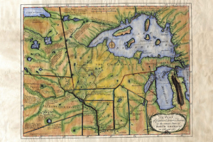
“Wow, I can’t begin to describe how beautifully painted my 1858 Plantation map is! Great communication with the artist. I highly recommend Lisa Middleton’s work!”  ~Mary Ann Carter, 12/12/2017

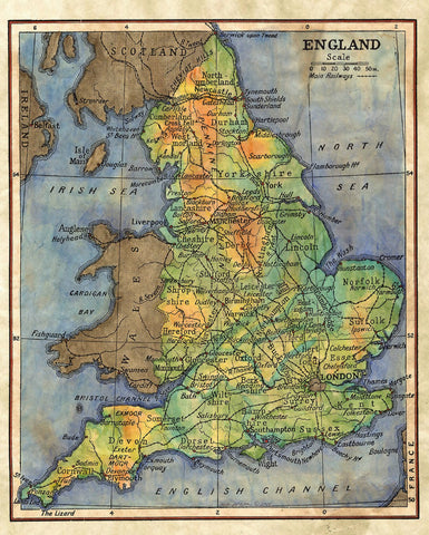
Our Collection of hand-painted Historic Maps is growing by leaps and bounds! Please use (blue) links to explore our maps and prints by category! Need a custom map of YOUR estate or favorite destination? Please PHONE 888-255-7726

CLICK HERE TO SEARCH our Map shopping site by any KEYWORD… date, cartographer, locale, state, etc. If you don’t find it, Call us! 888-255-7726

Gosh, better yet… Give YOURSELF a gift print! Sign up for a FREE weekly map raffle HERE!

Hand painted originals available now! Usual wait period is 1 month! 

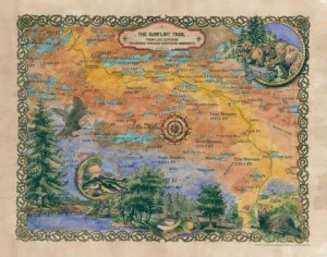
Top selling Pacific Northwest and Rocky Mountain maps

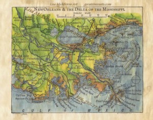
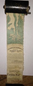
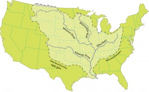
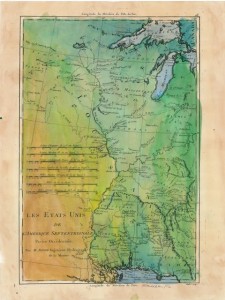
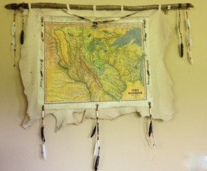
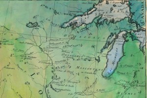
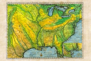
Mississippi River Historic Map Collection

Special Gift set of Mississippi River Guidebooks and the 1887 map of the Mississippi Riversave $20 on the set!

Discover! America’s Great River Road: Heritage and Natural History Guidebooks 

East coast Collection 

Eastern Florida

Western Florida

Custom Framing Services   

Old Time Railroad Stories in three volumes

Steamboating on America’s Rivers!

Special Pricing our most popular Book and Map RIVER BUNDLE… Great River Road/Mississippi River Guides and SAVE $30!

Perfect for Gift Giving! Need extra maps? Everyone who loves our 1887 map by Lisa Middleton will love Discover! America’s Great River Road, our comprehensive guide to life along the river for their favorite section!  Just CLICK HERE to purchase additional maps!

All Great River books can be ordered activity cover
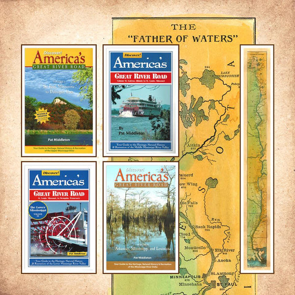
individually as well. CLICK HERE to go Straight to BOOKS on our new Shopping Cart at Great River Arts.

Let us know if you have any questions!


Great River Map Artist is in the news again!

Map Artist, Lisa Middleton, got her start on the Mississippi River, but she is truly nationally know for her custom designed artisan maps as well as her extensive body of hand painted historic maps. Her summer home is Montana, and the Northwestern market is keeping her busy. See ALL Lisa’s maps at www.greatriverarts.com

No automatic alt text available.

Exploring Lake Superior’s North Shore!

Enjoy exploring Lake Superior’s north shore through the eyes of our map artist and the early explorers! Thank you, Courtney for writing us! See maps at www.greatriverarts.com   Entire map title or region in a Search Box.

5 out of 5 stars
“I’m absolutely in love with these maps! My fiance and I purchased these to go along with pictures we took while visiting the boundary waters and these maps are the icing to the cake!”   Courtney

7A737DD6-4EB0-41D6-A52D-3772D8896675-324-0000002B5F586647

Boundary Waters, custom artisan design by Lisa Middleton

IMG_1587

Custom map by Lisa Middleton  A fun combination of past and present!

t!IMG_0923

Carver’s historic map of his travels includes so many historic notes… and the Grand Portage is carefully noted by extra large dots!

C6291F21-62BE-40C8-9288-FB6A822FA35D-324-0000002B638C4759

The Gunflint Trail includes lots of local landmarks which will have you remincing about when you went where and with who!

Lisa’s maps are available all along the Gunflint Trail and at many better gift shops along Hwy 61… or visit www.greatriverarts.com and search for Lake Superior maps!  Have fun!


If Spring Means HIKING! Here’s a Beautiful New MAP Collection just for you!

Great River Arts has just released a new collection of Hiking Map Gift Prints that range from Wisconsin’s Ice Age Trail to Mt. Kilimanjaro and the San Juan Islands off Washington State!  Click QUICK VIEW to see all maps at a glance. Click on any map image on the QUICK VIEW page to see specific maps in detail. Normally priced at $31.25, you can get a 15% discount by using the code take15  Your net cost: $24.95
3125   QUICK VIEW
Custom map of the Boundary Waters Canoe Area

Custom map of the Boundary Waters Canoe Area

3125   QUICK VIEW
215 The Ice Age Trail Map, Wisconsin Designed by Lisa Middleton

215 The Ice Age Trail Map, Wisconsin Designed by Lisa Middleton


168 Hiking trails of Hixon Forest, LaCrosse WI

168 Hiking trails of Hixon Forest, LaCrosse WI

Continue reading

Small Boat Cruise on the Shannon River, Ireland!

The PBS special on exploring the Shannon River in Ireland reminds me that we have several pieces on Ireland you may like to View. Clicking the BLUE links or the photos will take you to the stories and our shopping cart with zoom lens for the historic maps.

Click photo of the SHANNON PRINCESS to see our full review of visiting Ireland with Gourmet Chef, Olivia Powers.WATERWAY CRUISE REPORT
Cruising the Irish Heartland on the SHANNON RIVER
with the Shannon Princess

or use the SEARCH BOX upper right, to find more recent Ireland-related pieces on greatriver.com

Passionate Ireland! In conjunction with our river cruises, we generally do a two week land tour. Click Blue Link for our view of “Passionate Ireland.”

For Map Buffs, here is Ireland and the British Isles. These are all from an 1906 series by English Cartographer, John Bartholomew. I love the colors painted by the map artist, and the fact that RAILROADS are the featured mode of transportation rather than highways!

Click the image to find more about the history and how to purchase each map.

038 England 1906

113 Scotland 1906   057 Ireland 1906

Map art is available in numerous sizes and as note cards. Click on images for details.

New Railroad Anthology by Michael Gillespie now available!

New from Michael Gillespie, THE PHANTOM BRAKEMAN and Other Old Time Railroad Stories from the Era of Steam
ISBN 978-0-9711602-6-2, 172 pages, $19.95. Also available to museums and gift shops.

Phantom LR book coverPlease call 608-457-2734 to ORDER your books for immediate shipping.

As with all our books by steam historian, Michael Gillespie, this collection is full of historic photographs, entertaining tales from the days of steam railroading, and witty, insightful editorial commentary!

If you enjoyed COME HELL OR HIGH WATER, WILD RIVER WOODEN BOATS, or OLD TIME RAILROAD Stories, you will want to add this quality book to your steam collection.

Railroad buffs will also enjoy our broad selection of gift prints of Railroad maps! Please visit greatriverarts.com > SHOP and then enter railroad maps into the SEARCH button. We have maps for many individual lines and states. Also, all maps in the 1906 series include rail lines from that time frame.  NO_DELTA_MAP_small


Historic River Ribbon Maps Tell a LONG Story!


Mississippi River Ribbon Maps
Ribbon map with Winder, The image is printed on matte archival photographic paper with no border. The paper measures 60 inches on the longest side and is variable on the shorter side according to the shape of the photograph.

Story is adapted by Pat Middleton, www.greatriver.com, from an article by Bob Mullen, for The Paddlewheel newsletter published by the Golden Eagle River Museum, St. Louis, Missouri

(Left) Authentic Historic Ribbon map with Winder, sized for use on the boat. 


Imagine a map of the Mississippi River that shows all of the cities and towns along the river and all the landings where a steamboat might stop.

Make the map about three inches wide and in one continuous strip showing the entire river from the Gulf of Mexico to its source at Lake Itasca, Minnesota. If you imagined correctly, you would have a map that is about eleven feet in length, like a long streamer or ribbon. Now roll up the map to a couple of inches in diameter and put into a wooden cylindrical container that can easily fit into your pocket!


Continue reading

Drainage Map of the Mississippi River and its Tributaries. Some Facts and Figures

QUESTIONS! QUESTIONS!
For Jack, who wants to know more about all the tributaries of the Mississippi River: how many there are,  their names, and how long they are!

NPS.gov watershed tributaries

There are some 250 tributaries of the Mississippi which drain a total area of more than 1,247,000 square miles–one third of the nation’s landmass–extending from the Allegheny Mountains in the east to the Rocky Mountains in the west!

Remember the Mississippi River Flood of 1993? It wasn’t just the Mississippi River flooding that wreaked havoc, it was that all those tributaries flooded as well! At one point, the volume of water flowing past St. Louis was eleven times the volume of Niagara Falls!!

We start here with quick facts on the Mississippi River and several navigable tributaries! Please follow links for a little more depth of historical interest and to see our collection of hand-painted maps!

The Mississippi River, from its source at Lake Itasca in Minnesota, to the Gulf of Mexico, is approximately 2,348 miles long. The combined reach of the Missouri-Mississippi Rivers is 3,741 miles–a length exceeded only by the Amazon and Nile rivers. The Mississippi River has shortened by several hundred miles since the days of Mark Twain. Even today it varies 30-50 miles each year.

The widest navigable part of the Mississippi is Lake Pepin, on the Upper Mississippi, where it is approximately 2 miles wide. The average current flows from 1.2 miles per hour nearer Lake Itasca, and about 3 mi per hour nearer New Orleans.

Our Mississippi River Ribbon Map has been a best-selling Gift for many years. Lisa now offers her own custom ribbon map designs of both the OHIO RIVER and the Missouri River. Please click on any map image for more info on the map or the tributary. Or PHONE 888-255-7726 to order any map. Mention you saw it on greatriver.com for a one time 10% discount!   Click on map images for more info on the tributaries.

Continue reading

Happy 168th Birthday, Wisconsin!

Let us celebrate with historic French maps! Click on the maps to read detailed histories from Great River Arts… Lisa Middleton, Map Artist.Pause the curser over the map image and a magnifying glass with allow you to study the maps!!

We will do a different century through this coming week! First, the 18th Century.

Les Etats Unis  1765 (approx)

chief map on deerskin

Iowa/Wisconsin Territory

Les Etats Unis cropped

Les, Etats Unis, detail of Upper Mississippi River… “The Source of the River is Unknown..”

Ft Beauharnois pencil sketch

Ft Beauharnois near today’s Frontenac Minn

image

1731, De L’Isle’s CARTE DE LA LOUISIANE… With Lake Pepin Named on the Upper Mississippi River…. name requested by King Louis 14th!