You never know what you might find on Amazon, and today I discovered they are offering a FREE promotional Kindle version of Michael Gillespie’s COME HELL OR HIGH WATER, A Lively History of Steamboating on the Ohio and Mississippi Rivers. That seldom happens, to my knowledge, so I am happy to share this brief opportunity with you. If you enjoy this excellent Kindle version Steamboat Anthology, please be sure to review it!
True Stories of Steamboating on the Missouri River from one of our favorite steam era authors! In Come Hell or High Water, Gillespie invites the reader to experience the challenge that was steamboating in the nineteenth century–as recorded firsthand by passengers, crew members and journalists. Dozens of historic photos, charts, maps and Illustrations.
“For one brief moment in history, it was possible to slide down a muddy bank, board a steamboat, and travel anywhere within a 16,0000-mile system of inland waterways known as the Western Rivers. They included the incomparable Mississippi River…”
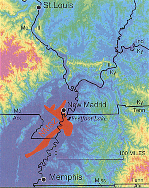
Is the big one about to hit the central United States? Maybe not, but a recent swarm of medium-sized earthquakes in Missouri’s New Madrid region has residents on edge.
The area of the New Madrid fault is the site of the nation’s most powerful earthquakes ever east of the Rocky Mountains which occurred in 1811–12 and caused the Mississippi River to flow backwards. This same area experienced six quakes on Monday, September 30, 2019, according to officials with the United States Geological Survey.
Two larger quakes were originally reported as 2.8 in magnitude each. They were later each downgraded to 2.7 magnitude. The third large quake was originally reported as a 2.7 magnitude. It was later downgraded to a 2.6 magnitude. A sixth was recorded later in the day.
All six recorded earthquakes on Sept 30, 2019 include:
According to the USGS, there have been 12 earthquakes in the past seven days in the Heartland. Click on the blue links for detailed info from the USGS.
If an earthquake the size of the 1811-12 earthquake hit today, cities from St. Lto Memphis would see extensive damage in the hundreds of Billions with a loss of possibly thousands of lives. Midwestern cities typically do not have building codes that account for earthquakes because of their relatively rare occurrence.
Fall Foliage Hot Lines from greatriver.com Try this new Prediction Map for the entire US! It says Smoky Mountains, but it is actually the whole country! https://smokymountains.com/fall-foliage-map/
Treasure Hunting is a perfect outdoor activity for cool and colorful days. Our beginner’s guide to Treasure Hunting along the Mississippi River is a favorite among our readers! Available now from AMAZON Books for just $2.99.
While mid-October seems to be the time when Fall Foliage really POPS along the Upper Mississippi River, we on the Upper River are certainly already seeing brilliant red sumacs. Softwoods are starting to yellow up. You can follow the southward march of Fall Color with the contacts below. Weather is perfect, enjoy the drive!
And don’t leave home without the indispensable guides to Mississippi River and Great River Road travel! Every volume of DISCOVER! America’s Great River Road is filled with a variety of fascinating Mississippi River fact and lore. Photos, maps, charts! All Volumes contain info on birding, wildlife viewing hotspots. Each highlights Geography, interpretive history and natural history attractions along the Great River Road.SAVE $10!!!
Click HERE to PurchaseDiscover! America’s Great River Road… St. Paul, Minnesota, Discovr! Guides are available in four volumes from St. Paul to Venice, Louisiana, individually signed by the author. Available on Amazon as paperback ($22) or KINDLE guide (9.99). Or phone 888-255-7726 and we will send you your copy TODAY.
The unglaciated region of western Wisconsin, northeastern Iowa, northwestern Illinois, and southeastern Minnesota is a natural and beautifully sculpted landscape that is known as the Driftless Area. The area is considered “Driftless” because it was not shaped by the movement of glaciers thousands of years ago. A part of the attraction to the region is the forested hillsides that extend into deeply carved river valleys that cut into limestone bedrocks. A key feature that makes the Driftless Area a unique place is the Baraboo Range, comprising of a collection of monadnocks- huge masses of rock rising up out of the middle of a plateau. The Driftless Area is a strange combination of plateau, deep river gorges, sinkholes, bluffs, and monadnocks.
The Driftless Area covers about 20,000 square miles, which primarily extends into western Wisconsin-roughly 85 percent. The landscape has plenty of caves, notably Viroqua City Cave and Cave of the Mounds, and the most rugged part of Driftless Wisconsin is the Ocooch Mountains. In southeastern Minnesota the Driftless Area begins at Fort Snelling, Minnesota, at the confluence of the Minnesota and Mississippi Rivers. This region is defined by vegetation of mixed woodland, goat prairies, and old plateau covered by loess. The Minnesota River cuts across the Driftless Area. In Driftless Iowa the landscape is of forested valleys, streams, rivers, and majestic limestone bluffs. In Illinois, rolling hills and wooded ridges, and features such canyons, ravines, bluffs, and palisades makes up its portion of the Driftless region
The Driftless Area’s forests, prairies, wetlands, and grasslands provides ideal habitat for wildflowers and wildlife. Farming continues to be an activity that thrives in the Driftless Area. Unique soil conditions and higher elevations are ideal for growing particular crops. Amish farmers have long situated themselves in the region, but a new breed of organic farmers has emerged in Driftless. Wisconsin in particular, has expanded into a hotbed of organic farming. The Driftless Region is also ripe for fishing for a variety of trout including brown trout, rainbow trout, and brook trout. Whitetail deer and wild turkey, ring-necked pheasant, along with other games such as ducks and geese, grouse, quail, mourning dove, rabbit, squirrel, raccoon, fox, and coyote can all be hunted in specific portions of the Driftless Area.
Lisa Middleton’s provides a detailed mapping of the region, and depicts particular features that partly shape the region. The Driftless Region is simply a beautiful and diverse landscape that is like no
I had fun previewing a new line of home decor and totes featuring our own Driftless Region and Pool 8 Retailers let me know if you’d like more info ! Use the discount code patspecial and we will call you with details.
Right now, Lisa is offering discounted pricing for our valued customers, however, she has a minimum of 4 for any item ordered. So bring your CHRISTMAS LIST! All major credit cards accepted.
Map Artist, Lisa Middleton will display a full selection of beautiful original map art and fine art prints at Art Fair on the Green, in La Crosse, Wisconsin, July 27-28, 2019.
Clickgreatriverarts.com, for a sampling of Wisconsin, Minnesota, Great Lakes, and Minnesota map art.Or choose any other key word to explore many 100s of historic and custom map designs in Lisa’s gallery!
I am beginning to relive some of the trauma of life along the Middle Mississippi Mississippi during 1993. Valmayer, Illinois, is back in the news as the community works desparately to fill 25,000 sandbags, and flooding at the confluence of the Missouri and the Mississippi near St. Louis has caused widespread flooding. During 1993, which closed down commercial shipping on the river for many months, I traveled the river frequently. ALWAYS it was stomach-wrenching!
The Flood of 2019 has now been ongoing some 82 days… since MARCH for folks in the Middle Mississippi. As we watch the current flood peaking in the next week, and hear about “levee boils” and breaks in the levees, it is worth noting that in 1993, the first dam did not burst until June 20th in Wisconsin. It was August 2 before the Mississippi crested at 49.7 feet in St. Louis. Today, rains still fall from Oklahoma to Louisiana, impacting both the Missouri and the Lower Mississippi Rivers. 2019 has been a record flood in terms of the time it has been affecting those who live along the Mississippi and its tributaries.
First a Chronology of the Flood of 1993, compiled by Pat Middleton, Greatriver.com
1993 Mississippi Flood CHRONOLOGY
March 10 The National Weather Service predicts below normal precipitation for the summer: “but above average rainfall could mean flooding, given soil saturation, spring snow depths, and normal spring rains.” June 10 The first 8” rainstorms begin in Dakotas, Wisconsin and Minnesota June 20The first dam bursts, submerging 100 homes to their rooftops on the Black River in Western Wisconsin. The upper 200 miles of the Mississippi River are closed to river traffic. Locks and Dams are not operating. July 5 The bridge at Keokuk closes. July 10 The bridge closes at Fort Madison, Iowa, which has experienced rain for 54 of 58 days. 830 miles of Mississippi River are closed to boat traffic between Cairo, Illinois and St. Paul, Minnesota. Over 100 rivers feeding into the Mississippi River flood by July 14. Unprecedented high-water on the Missouri River, Des Moines River, Illinois, Iowa, Skunk, Rock and Raccoon rivers (all tributaries of the Mississippi River) promote the massive flooding of the Mississippi River. July 16 The last Quincy, Illinois, bridge is closed, leaving no bridge between Alton, Illinois and Burlington, Iowa. The Mississippi River is flooded to seven miles inland. July 24 The Mississippi River at Quincy crests at a record 32 feet. August 2 The Mississippi River crests at 49.7 feet in St. Louis, Missouri. Eleven times the volume of Niagara Falls is flowing under Eads Bridge; enough to fill Busch stadium every 65 seconds. August 24 The Mississippi River locks reopen to commercial river traffic. August 30 The Des Moines River floods again, after another 10 inches of rain falls. The Mississippi River stays open.
Sandbags and Stuff (Statistics collected from various regional newspaper sources.)
These stats offer a base for comparison as states come out for the Flood of 2019.
Estimated that two truckloads of sand (a little less than fifty tons) will fill 4000 sandbags.
More than 26.5 million sandbags were used in towns along the Mississippi River during the Flood of 1993
Approximately 927 million pounds of sand was used to fill those sandbags
Homeowners had to fill their own sandbags
In all, 150 primary and secondary levees failed during the summer.
12 billion dollars in damages
48 deaths
nine states involved
1 inch of water on an acre of land equals 27,143 gallons.
Rich and I had great fun recently presenting as our 1830s characters to the Congregational Preschool in La Crosse!
As “Mrs. Phelps, I talked about my life in wild Iowa and displayed furs traded by members of the Keokuk tribe… fox, mink, beaver, deer, and, for fun, a Kangaroo!
“Old John” found an avid audience for his bird calls, clam shells, and turtle skeleton. Fun for Everyone!!
“We liked the bird noises.” “The animal claws were neat!” “I liked the bunny purse.” “The skins were so soft!” “We liked looking at shells.”
Thank you, Dennis, for a great report on where to see eagles in PDC!
Last evening there were over 200 Bald Eagles roosting in the normal
migration roost site near the Barn Restaurant north of Prairie du Chien
on Cty Rd K. This roost is in the tree line west of the dry docked tow
boat south of the restaurant. Very little open water was present for
feeding activity. The small spring and open water at the Winneshiek
Marina had 12 White Pelicans that were feeding on the few dead shad seen
floating at that location. With the expected rise in the Mississippi
River water level, because of rain and snow melt, open water should be
present around the edges of Gremore Lake. The water level was at 9.5
feet Wed. This morning it is at 11 feet and is expected to go to 17 feet
by Tues or Wed. Water goes over the Ambro Road on the north side of
Gremore Lake at 13.4 feet. With that amount and volume of water river
ice will be moved, or at least raised . More open water where eagles
can feed on dead shad will be present. Other sloughs in and around
Prairie du Chien are starting to open as well. If the eagles and
pelicans move to Gremore Lake as they have in the past the best location
to see the birds is from the riverside parking lot of the Crooked Oar
Bar and Restaurant. In the past 3 years over 500 eagles were seen on
and near Gremore Lake during the migration stop over they make during
mid-March.
Every year the day arrives when I can say “spring has sprung in the valley,” Today was that day! 49 degrees. Sandhill cranes, redwing blackbirds, Canada geese, a pair of trumpeters, a turkey vulture, a Valley awash in snow melt. While it seems late compared to recent arrival dates, a quick review of past Sandhill arrival dates shows that the cranes arrived right on schedule.
March 15, 2009 “Bitter cold night as late as 03/13/09. So cranes waited until we hit the 50 degree mark two days later.“
March 12, 2008 “3 Sandhill cranes fly over Goose Island near La Crosse.
March 13, 2008 A Single crane flies, calling, over Coon Creek near Stoddard. Lots of melting snow in the valley. Temp of 56.7 degrees. ”
March 11, 2007 “Sandhill Cranes on the islands off Goose Island Park south of La Crosse. Temps in upper 40s, two weeks after record snowfalls in Western Wisconsin, so lots of snow on the ground. March 12 the cranes are reported along Coon Creek and other valleys off the Upper Mississippi River.”
Feb 23, 2005 (a good two weeks earlier than normal!) March 15, 2003 March 13, 2002
March 13, 2001
March 16, 1999 March 1, 1998 March 10, 1997 March 13, 1996 March 18, 1993 April 4, 1992 March 9, 1988 March 17, 1987

![Come Hell or High Water, Volume 1 (Kindle Edition): True Tales of Steamboating on the Mississippi and Ohio Rivers (The Era of Steam) by [Gillespie, Michael]](https://images-na.ssl-images-amazon.com/images/I/417uyNqlfvL.jpg) You can also purchase the perfect bound paperback of 300 pages direct from the publisher HERE.
You can also purchase the perfect bound paperback of 300 pages direct from the publisher HERE.


 The Driftless Area covers about 20,000 square miles, which primarily extends into western Wisconsin-roughly 85 percent. The landscape has plenty of caves, notably Viroqua City Cave and Cave of the Mounds, and the most rugged part of Driftless Wisconsin is the Ocooch Mountains. In southeastern Minnesota the Driftless Area begins at

 Plush Throw $52
  Comfy Pillows $28
 Sturdy Canvas 18″ Totes $31

 Rich and I had great fun recently presenting as our 1830s characters to the Congregational Preschool in La Crosse!