Hot off the Press! The Delta Queen hasn’t been written off yet!
WASHINGTON (AP) –
The Delta Queen could be back cruising waterways sometime soon.
The Senate voted 85-12 on Monday to allow the legendary riverboat to carry passengers if certain safety changes are made to the wooden vessel. In the past, the Delta Queen had been exempted from a 1966 law that had prevented wooden boats from carrying passengers overnight. That exemption lapsed in 2008.
Sen. Claire McCaskill of Missouri, a sponsor of the measure, appealed to her colleagues to help return the “Delta Queen to her rightful place on the mighty Mississippi.”
McCaskill said three presidents rode on the Delta Queen – Herbert Hoover, Jimmy Carter and Harry S. Truman. She said the boat operated for decades without incident.
The House still must act on the bipartisan bill.
Copyright 2017 The Associated Press. All rights reserved.
New from Michael Gillespie, THE PHANTOM BRAKEMAN and Other Old Time Railroad Stories from the Era of Steam
ISBN 978-0-9711602-6-2, 172 pages, $19.95. Also available to museums and gift shops.
Please call 608-457-2734 to ORDER your books for immediate shipping.
As with all our books by steam historian, Michael Gillespie, this collection is full of historic photographs, entertaining tales from the days of steam railroading, and witty, insightful editorial commentary!
If you enjoyed COME HELL OR HIGH WATER, WILD RIVER WOODEN BOATS, or OLD TIME RAILROAD Stories, you will want to add this quality book to your steam collection.
Railroad buffs will also enjoy our broad selection of gift prints of Railroad maps! Please visit greatriverarts.com > SHOP and then enter railroad maps into the SEARCH button. We have maps for many individual lines and states. Also, all maps in the 1906 series include rail lines from that time frame.
Story is adapted by Pat Middleton, www.greatriver.com, from an article by Bob Mullen, for The Paddlewheel newsletter published by the Golden Eagle River Museum, St. Louis, Missouri
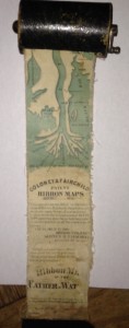
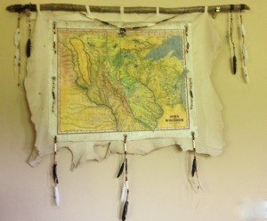
(Left) Authentic Historic Ribbon map with Winder, sized for use on the boat.
Imagine a map of the Mississippi River that shows all of the cities and towns along the river and all the landings where a steamboat might stop.
Make the map about three inches wide and in one continuous strip showing the entire river from the Gulf of Mexico to its source at Lake Itasca, Minnesota. If you imagined correctly, you would have a map that is about eleven feet in length, like a long streamer or ribbon. Now roll up the map to a couple of inches in diameter and put into a wooden cylindrical container that can easily fit into your pocket!
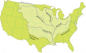
For Jack, who wants to know more about all the tributaries of the Mississippi River: how many there are, their names, and how long they are!
There are some 250 tributaries of the Mississippi which drain a total area of more than 1,247,000 square miles–one third of the nation’s landmass–extending from the Allegheny Mountains in the east to the Rocky Mountains in the west!
Remember the Mississippi River Flood of 1993? It wasn’t just the Mississippi River flooding that wreaked havoc, it was that all those tributaries flooded as well! At one point, the volume of water flowing past St. Louis was eleven times the volume of Niagara Falls!!
We start here with quick facts on the Mississippi River and several navigable tributaries! Please follow links for a little more depth of historical interest and to see our collection of hand-painted maps!
The Mississippi River, from its source at Lake Itasca in Minnesota, to the Gulf of Mexico, is approximately 2,348 miles long. The combined reach of the Missouri-Mississippi Rivers is 3,741 miles–a length exceeded only by the Amazon and Nile rivers. The Mississippi River has shortened by several hundred miles since the days of Mark Twain. Even today it varies 30-50 miles each year.
The widest navigable part of the Mississippi is Lake Pepin, on the Upper Mississippi, where it is approximately 2 miles wide. The average current flows from 1.2 miles per hour nearer Lake Itasca, and about 3 mi per hour nearer New Orleans.
Our Mississippi River Ribbon Map has been a best-selling Gift for many years. Lisa now offers her own custom ribbon map designs of both the OHIO RIVER and the Missouri River. Please click on any map image for more info on the map or the tributary. Or PHONE 888-255-7726 to order any map. Mention you saw it on greatriver.com for a one time 10% discount! Click on map images for more info on the tributaries.
Let us celebrate with historic French maps! Click on the maps to read detailed histories from Great River Arts… Lisa Middleton, Map Artist.Pause the curser over the map image and a magnifying glass with allow you to study the maps!!
We will do a different century through this coming week! First, the 18th Century.
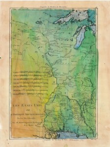
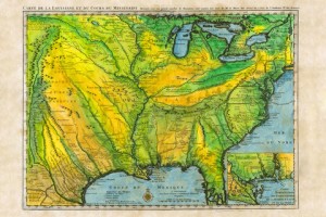
Les Etats Unis 1765 (approx)
Iowa/Wisconsin Territory
Les, Etats Unis, detail of Upper Mississippi River… “The Source of the River is Unknown..”
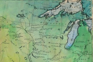
Ft Beauharnois near today’s Frontenac Minn
1731, De L’Isle’s CARTE DE LA LOUISIANE… With Lake Pepin Named on the Upper Mississippi River…. name requested by King Louis 14th!
The two eagles born this year are just about ready to take flight, but years of observation and study at the nest has resulted in several detailed reports posted to the site on the Eagles we have watched grow up there.
For example, here is an eagle’s eye view of how our adult eagles differ in appearance, with a U Tube commentary from the Raptor Resource Center: https://youtu.be/5lARYcL5A50 Click to have a look. See also the history of Eaglets fledged in the last year, nesting behavior, and more!
Perfectly gorgeous Fall weather…with day-time highs in the lows 60s… should continue for another week and a half into October. Get out and enjoy! Color will make a steady march south for the next several weeks. Hardwoods (hickories, maples, and finally, oaks) have begun to illuminate the bluffs! Red, and sugar maples (yellow), love the southeast facing slopes near Lansing and Mc Gregor, Iowa.
Check out the march of color in the next post. Call hotlines ahead or check online for best color in the 10 Mississippi River states!
A few bright yellow aspens and birch still have their leaves, and hickories are sporting some orangish brown. The last leaves to drop are the oaks, so once the bluffs turn a rich uniform brown, we know the color season has nearly ended. Softwoods in the river bottoms are steadily losing leaves that never become really brilliant.
Additionally, Hummers are gone, and Sandhill cranes departed our valley. Pelicans have gathered up along the river and look like heavy clumps of pure white snow. Egrets and Great Blue Herons are still on the backwaters. Duck hunting is in full swing and adult American Bald Eagles are abundant! Color is great, but lots more to see along your route!
It’s fall and few locations in the country offer the same natural beauty as the easel-like bluffs of the Mississippi River Valley. We’ll keep you posted on color hot-spots as the season progresses, but you will also find the following sites and hotlines of interest. Peak color periods for each state are noted in paragraphs.
Arkansas. 800-628-8725; www.1800natural.com (late October to early November)
And don’t leave home without the indispensable guides to Mississippi River and Great River Road travel!
Every volume of DISCOVER! America’s Great River Road is filled with a variety of fascinating Mississippi River fact and lore. Photos, maps, charts! All Volumes contain info on birding, wildlife viewing hotspots. Each highlights Geography, interpretive history and natural history attractions along the Great River Road.SAVE $10!!! Purchase ALL FOUR VOLUMES of Discover! America’s Great River Road… St. Paul, Minnesota, to Venice, Louisiana, individually signed by the author. Four guides for $62.
Ribbon Map of the entire Mississippi,
including Lake Glazier, MN. 1887
Drawn by Willard Glazier
This ribbon map was drawn by Captain Willard Glazier to “prove” his premise that the True Source of the Mississippi was Lake Glazier rather than Lake Itasca. Many modern-day towns are included in this survey, including Point Coupee in Louisiana. Many towns noted on the map…such as Waterproof… no longer exist!
“Mississippi
River Ribbon Maps”
from an article by Bob Mullen, for The Paddlewheel newsletter.
Imagine a map of the Mississippi River that shows all of the cities and towns along the river and all the landings where a steamboat might stop. Make the map about three inches wide and in one continuous strip showing the entire river from the Gulf of Mexico to its source at Lake Itasca, Minnesota. If you imagined correctly, you would have a map that is about eleven feet in length, like a long streamer or ribbon. Now roll up the map to a couple of inches in diameter and put into a cylindrical container that can easily fit into your pocket!
Such maps do exist. In 1866, Myron Coloney and Sidney B. Fairchild patented and published a map like this in St. Louis. In 1887, explorer Willard Glazier produced another ribbon map that included a lake he called Lake Willard, which he believed was the TRUE source of the Mississippi River. The 1866 map was sold commercially in St. Louis and along the river for a number of years. The maps were housed in a wooden cylinder with a rounded wooden cap at each end. On the side, a slot was cut where the map could be pulled out to give people a way to grasp it when pulling the map from its case. The patent granted the inventors was for “the idea or design ofmaps upon strips of any material,” as stated on the map itself. Glazier’s 1877 map was folded and printed with the guide to his canoe trip from Lake Willard in Minnesota to the Gulf. It includes most of the river villages we know today, as well as many which have since been washed away by Mississippi River flooding.
These maps both show considerable detail, but could never be used by a steamboat pilot for serious navigation. The river was much to complicated with islands, tricky bends, wing dams, and other obstacles to fit on a map like this. The ribbon map must have been made for the tourist or other traveler on the river who had enough expendable money to pay for such a souvenir. While the boat’s pilot had a detailed map to follow (often only in his memory), these ribbon maps served the traveler with a way to keep track of the boat’s progress on a long trip. It even pointed out a few points of interest. A notice in the July 10, 1866 Missouri Republican stated, “To the traveler, it will be an exciting guide and companion, and will furnish him with more information at a glance than he can secure from a constant questioning of the officers of the boat… to say nothing of avoiding a short answer from, or an immensity of annoyance to, these monarchs of our Mississippi River palaces.”
Only a handful of original ribbon maps exist today, scattered in museums across the country. The Smithsonian has one and the Missouri Historical Society of Missouri owns three Mississippi River ribbon maps. Each of these is extremely fragile and can no longer be handled. One of the maps at MHS is about eight inches wide, and has all the detail a riverboat pilot would need. Housed in a larger wooden box with a glass window, the map winds from a roll on one side of the window to a box on the other side of the window. The map in the window only shows an area some 30-40 miles… new scrolls could be set in place as the pilot traveled the length of the river.
In the 140 years since the first ribbon map appeared, nearly every one has disappeared. The Willard Glazier Reproduction here on www.greatriver.com is the only ribbon map we know of that is still available for sale to the public. Each map is either hand-stained to a sepia tone and parchment feel or is exquisitely hand-painted for framing.
Click here to see ALL of our beautiful antique Mississippi River maps online. Email or phone 888-255-7726 for more information!!
5×7″ notecards with portions of the painted maps are available for $4.95 each. Call for information or to request a certain map portion that is meaningful to you.
If you have friends in the Northwest, this is a good time to let them know about Lisa Middleton’s historic map paintings. Lisa is beginning her national show schedule in Montana/Washington/Colorado. Her Updated show schedule can always be seen at www.greatriverarts.com

 Please call 608-457-2734 to ORDER your books for immediate shipping.
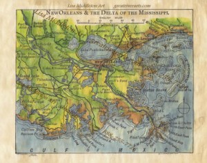


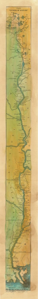 Ribbon Map of the entire Mississippi,