FERRYVILLE — The Ferryville Tourism Council will host its annual Fall Migration Day from 9 to 11 a.m. Saturday, Nov. 10, in River View Park on Highway 35.
Additional birding events will be held beginning at 8 a.m. at the Driftless Center in Lansing, Iowa, and from 10 a.m. to 2 p.m. at the birding observation area at Brownsville, Minn., Hwy. 26, all on Nov. 10.
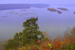
If you haven’t had the opportunity to explore the excellent DRIFTLESS CENTER in Lansing, Iowa, do take advantage of this opportunity. Enjoy the huge deck/porch that offers a wide view north toward the historic Lansing Bridge. There have been eagles in the vicinity each time I’ve visited.
Additionally, the displays capture our river heritage as well as any museum north of Dubuque. Live snakes, including a timber rattler, our clamming heritage, driftless geography, commercial fishing and more. Great for kids AND adults.
Save 40% UNTIL APRIL 26 on any of TWO of our $19.95 books atGREAT RIVER ARTS!Order on line and use the Discount Code FOLKS at checkout. (No other discounts apply) Order to 888-255-7726. Or Phone your Order to 888-255-7726.
“Mike’s Railroading books are for people who love to immerse themselves in the days of Steam. They are colorfully written, well-edited and take one through a gamut of emotions. You will read them more than once!” ~ Purchaser comment
This is a great opportunity also to Purchase all FOUR of our DISCOVER! AMERICA’s Great River Road series and SAVE 40% over the regular individual pricing! 1000+ pages of fascinating information about the Heritage and Natural History of the Mississippi River. A first class collection for Traveler and resident alike by River Author, Pat Middleton. Order on line at Great River Arts and use the discount code FOLKS or phone 888-255-7726 to order by April 26! We have never made an offer like this! Save more than $30!
Larger format FINE ART Prints (18×20 and larger) of ALL Lisa Middleton Maps are available for 40% off at greatriverarts.com when you use the code FOLKS, at checkout.
This is an amazing opportunity for those who prefer a larger format of any map from Great River Arts. Only until April 26!! Check this out today! Or call 888-255-7726 to ask about having a CUSTOM MAP designed!
SPECIAL MAP OFFER for our river buffs: Purchase 2 of our newest custom designed maps and save 40%. Get BOTH MAPS for just $35. This is a special $62.50 value from Great River Publishing! Available by phone only. 888-255-7726
The DRIFTLESS Region map (above) captures portions of Minnesota, Iowa, Wisconsin and Illinois anchored by the Mississippi River.
Its corollary is the ICE AGE TRAIL that follows the moraines of the last Ice Age from Door Count, Wisconsin, to the St. Croix River and Minnesota border.
Perfect for Dad, a brother or other MAP buff in your family! Or keep one for yourself! Each map includes extensive historical and geologic notes.
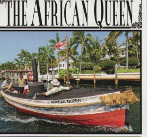
How fun is this? The actual little river steamer from the movie, AFRICAN QUEEN, with Katherine Hepburn and Humphrey Bogart is docked in Key Largo, Florida at Mile Marker #100.
I was able to take the helm and pilot it during most of our cruise, and the gentle put-put of the engine and its “naked” operation was a huge delight. The boat itself celebrated its 100th year in 2012. It has been fitted with an 1880s steam engine and is available for short sightseeing and Dinner cruises through the canals of Key Largo and out into the Key Largo Sound. It only carries a maximum of 10 people, there were 4 of us on our little excursion!
The iconic vessel was made famous in the 1951 movie of the same name and she still remains a timeless classic. This famous steamboat is available for daily canal cruises and dinner cruises in the Port Largo Canal area and also for private events. Engine and today’s diesel boiler.
A LITTLE HISTORY: The African Queen was built in Lytham, England in 1912 for service in Africa for the East Africa British Railways company. She was used to shuttle cargo, missionaries and hunting parties across the Victoria Nile and Lake Albert which was located on the border between the Belgian Congo and Uganda.
In 1951 she starred in the famous movie directed by John Huston. Afterwards she remained in service in Africa until 1968 when she was brought to the United States working in San Francisco, Oregon and Florida. She has been the pride and joy of Key Largo since 1982, where she is registered as a National Historic site and in 2012 celebrated her centennial year. Below is a video of the steam engine. It should be horizontal, not vertical!
It has been fitted with an 1880s steam engine and is available for short cruises through the canals of Key Largo and out into the Key Largo Sound. Below left shows the steam engine and boiler (diesel). I also tried to insert a video of the engine operating.
CONTACT: PHONE: 305.451.8080 Website: africanqueenflkeys.com There is a lot of interesting info on the boat, the movie, and the history of its service in Africa!
If the Florida Keys is one of your favorite places, check out our hand-painted historic and custom designed maps of Florida available for purchase or viewing by clicking HERE on our FLORIDA FINE ART MAP site!
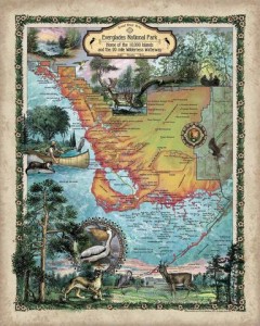
Everyglades LR
Find the Everglades, all five coasts of Florida, and beautifully painted historic hand-painted historic and custom designed maps of Florida by clicking HERE on our FLORIDA FINE ART MAP site!
Use the SEARCH BOX at Great River Arts to search ALL our extensive collection of Fine Art Maps from across the country and the world!!
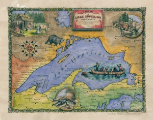
Enjoy exploring Lake Superior’s north shore through the eyes of our map artist and the early explorers! Thank you, Courtney for writing us! See maps at www.greatriverarts.com Entire map title or region in a Search Box.
5 out of 5 stars
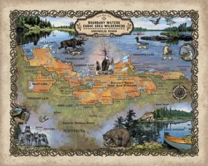
“I’m absolutely in love with these maps! My fiance and I purchased these to go along with pictures we took while visiting the boundary waters and these maps are the icing to the cake!” Courtney
Boundary Waters, custom artisan design by Lisa Middleton
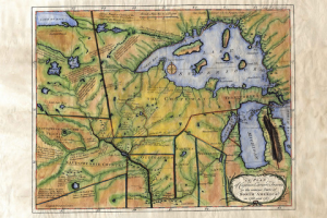
Custom map by Lisa Middleton A fun combination of past and present!
t!
Carver’s historic map of his travels includes so many historic notes… and the Grand Portage is carefully noted by extra large dots!
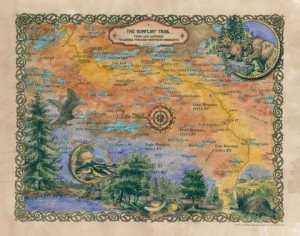
The Gunflint Trail includes lots of local landmarks which will have you remincing about when you went where and with who!
Lisa’s maps are available all along the Gunflint Trail and at many better gift shops along Hwy 61… or visit www.greatriverarts.com and search for Lake Superior maps! Have fun!
Thank you to my favorite photographer for his first Tundra Swan alert:
“After a long and arduous wait the Tundra Swans have finally arrived in number on Pool 8 of the Mississippi River. (Usually I am busy photographing along the MS during the whole month of November, but not this year.)
Enter Swans in the Search Box at the upper right to pull up historical arrival dates back to 2008! Interested in Eagles? Enter Eagles in Search Box… or anything else you are curious about!!
Marc Schulz of the La Crosse County Conservation Alliance said of the trespass issue, “There is no bigger issue regarding the river.” He added that greatests percentage of fatalities on the railroad happen at designated crossings. Schulz said that, “Young professionals come to western Wisconsin because of its natural resources.” He added that, “This is the people’s land and water.”
John Wetzel representing the Wildlife Federation said, “We need more state oversight. Minnesota has done that. He added that this isn’t just a Mississippi River corridor problem saying there are, “. . .hundreds of places in the state where this is a problem.”
Pat McCabe of De Soto said, “I have property on the other side of the tracks. I will not stop crossing.” He added, “I beg you make them (trains) slow down. Who are you going to call? (if there is an accident.)”
Guy Wolfe of Stoddard representing CARS-Citizens Acting for Rail Safety said, “There is a public trust doctrine law. We have a right to these waters.” He added that he has seen derailed cars on both sides of the tracks on “our property.” He urged people to photograph and report issues with the tracks and rail bridges. He said he feels that after reports about decaying rail bridges the railroad started enforcement of the trespass law. He said after letting the permit to repair the Coon Creek bridge at Stoddard expire, the railroad suddenly worked “24-7” to repair it. Wolf added that at least one bridge still in use along the river was built in 1867. He said, “We can’t afford to let (rail) bridges fail.”
Commissioner Wadhwa replied that, “The new fast act law requires that we put bridge inspection results on websites.”
Kirk Holliday of De Soto said that, “BNSF is making threats to the village sewer.” De Soto’s wastewater treatment plant is across the tracks on the river side. He added, “The government bails them (the railroads) out. They get billions to fix their problems and then they basically hold us hostage.”
Gary Moltert of De Soto told about railroad rolling stock that hauls Bakkum crude and ethanol. He said, “Double hulled tankers are safer. Canada is being very proactive enforcing this. Here investors have $80 to $90K in old tankers and the government allows them six years to replace them with safer cars.”
Commissioner Wadhwa replied, “We can’t do anything, but the feds and USDOT can.” He added that, “New tank cars constructed after 2015 and existing cars must be retrofitted and have an advanced brake system installed.”
Sherry Quamme, representing the Mississippi River Parkway Commission said that, “We’re concerned with Wisconsin issues for eight counties of the Great River Road . . . we want to see that there is legal pedestrian access . . . additional crossings are not the answer because it requires a large capital investment.”
Mike Collins of the La Crosse Snowmobile Alliance said, “We purchased a building across the tracks. We asked the railroad for a recreational crossing. We asked them for $6,000.” The railroad denied the request. Collins added, “They said it’s a safety issue. It’s not. It is straight and level for miles.”
Frank LeMay commented that, “Point of access changes won’t work because the river changes from day to day.”
Joan Wolfe of Stoddard asked about changing Act 179, “What’s the downside? Why wouldn’t the governor want to sign it?”
Senator Schilling said that, Assembly leader Van Wanggaard didn’t bring up the trespass law change proposed by 96th Assembly District representative Lee Nerison in the Assembly because, “Governor Walker would likely veto it and the Republicans in the legislature don’t want to be put in the position of overriding the governor’s veto.”
Phillip Hooker of Victory said that the railroad speed limit is too high. “It should be 45 mph max,” he said.
Monique Hooker of Victory expressed her concern about being able to do river cleanups, “The Friends of Pool 9 need to clean along the Mississippi and on the Wisconsin side. Students and volunteers need access to clean up the river banks. We have to look at the environmental issue and put your money where your mouth is.”
Ralph Knutson of De Soto said, “We need more rail inspections. There is no state accountability – no rail inspectors.” He added that, “The railroad is also interested in having only one person on a train to operate it to save money.”
Commissioner Wadhwa said that, “The federal safety board is taking comments on fewer crew.”
Senator Shilling added, “There is a bill in progress to improve emergency preparedness along the railroad and to train first responders to deal with (railroad) emergencies.”
A larger group attended the 1 PM session at Stoddard. More than half a dozen people said they had received trespassing warnings from BNSF officers. The railroad calls it, “ a public safety education campaign.”
Vernon County Sheriff John Spears asked those who received warnings if the officers were polite and courteous. They all replied, “No.” Spears who supports a compromise, told the Stoddard crowd that his deputies were not enforcing the law. “If anybody gets arrested, they’re not spending a night in my jail. That’s for sure,” he said.
Dick Jensen of Stoddard said, “It’s almost like that railroad track now is a fence.”
Richard Meyer of La Crescent, Minn. ““This whole situation has damaged the state’s reputation and the railroad’s,” he said. “People are furious.”
Mike Widner of Boscobel, “The only folks who will likely obey the laws are hunters, fishers and trappers.”
Stoddard Village President Kevin Gobel said, “The enforcement campaign started soon after rail safety groups and the village complained about the condition of BNSF’s bridges.”
It’s fall and few locations in the country offer the same natural beauty as the easel-like bluffs of the Mississippi River Valley. We’ll keep you posted on color hot-spots as the season progresses, but you will also find the following sites and hotlines of interest. Peak color periods for each state are noted in paragraphs.
Arkansas. 800-628-8725; www.1800natural.com (late October to early November)
And don’t leave home without the indispensable guides to Mississippi River and Great River Road travel!
Every volume of DISCOVER! America’s Great River Road is filled with a variety of fascinating Mississippi River fact and lore. Photos, maps, charts! All Volumes contain info on birding, wildlife viewing hotspots. Each highlights Geography, interpretive history and natural history attractions along the Great River Road.SAVE $10!!! Purchase ALL FOUR VOLUMES of Discover! America’s Great River Road… St. Paul, Minnesota, to Venice, Louisiana, individually signed by the author. Four guides for $62.
Bellevue State Park, near Bellevue, Iowa, just south of Dubuque, is located atop a 300-foot high limestone bluff with panoramic views of the Mississippi River valley and Lock & Dam 12. It also shelters the largest Butterfly Garden in Iowa.
The Garden Sanctuary for Butterflies contains over 100 separate plots, each featuring plants which provide nectar for adult butterflies and/or host plants for caterpillars. Pathways allow visitors to enjoy the wide variety of butterflies and flowers. An area has been established next to the garden to allow close-up viewing of the butterflies.
According to the Iowa Department of Natural Resources, butterflies found in Iowa are either in the process of migration or are completing one of the various stages of their life cycle. Approximately 60 species of butterfly can be expected to make their appearance at the Butterfly Garden each year. Host plants for butterflies include wild aster, ragweed, goldenrod, lamb’s-quarters, daisy fleabane, milkweed, cottonwoods, wild cherry, hackberry and willows.
ALMANAC, August 3, MONARCHS IN THE CEDAR TREE
c Pat Middleton. May not be reproduced or used in any format without permission.
beautiful monarch cluster DAVE COLLINS IMAGE
The gentle shift to fall is palpable around us. The sun sets southward, over the neighbor’s pathway, rather than behind the northern bluffs. Geese fly from cornfield to cornfield in great flocks. 64 degrees today, 40 tonight. We gather firewood.
For the second year in a row, a swarm of Monarch butterflies have set up camp in the old cedar in the side yard. They hang motionless from the branches–like dull brown seed pods–until a late-comer flutters by. Then all gently beat their orange-colorful “hello” and “where’ve you been” until the traveler, too, is accommodated comfortably to its own berth for the night.
September 6, 2015 Each night this week we have had a single Monarch roost in the old Cedar tree and we remember how we once saw 100s. It takes our nightly guest a long time to settle in… perhaps it too “remembers” that there should have been more of his fellows here…
Along the Mississippi by Ruth Nissen, Wisconsin DNR
Monarchs Ready to Head South
About this time of year we begin to notice more monarch butterflies fluttering in the wind and congregating (or staging) in areas where bountiful supplies of nectar are available.
But what isn’t readily apparent is that those butterflies are moving with a purpose and direction. Every year, in late summer and early fall, millions of monarch butterflies from the Eastern United States and Southern Canada find their way to Central America. This is a journey of more than 2,000 miles from the Upper Mississippi River.
The monarchs are heading to the Transvolcanic Mountain Range, located west of Mexico City, to spend the winter. They gather there in huge colonies of tens of millions of butterflies, literally hanging from fir trees in clusters so thick they look like bundles of dead leaves.
The butterflies arrive in November and remain largely inactive until undertaking the return trip north in mid-March. How they find their way is a mystery because the monarchs that leave Mexico in spring are at least three generations removed from those that will make the journey back in the fall.
Monarchs leaving the wintering areas migrate 800 miles to the Southern United States, where they lay their eggs. The next generation on monarchs continues the northward migration to the upper United States and Canada. This continued movement north is necessary because southern milkweed plants die out in June. Two to three more generations are produced during the summer before the monarchs begin to flutter their way back to Mexico.
About 12 wintering sites have been identified in this mountain range of central Mexico. The monarchs are attracted to the high altitude fir forest of these sites because the combination of temperature, humidity, and wind velocity create the conditions essential to their survival. The canopy of the fir trees also protects them from large temperature fluctuations and winter storms.
Unfortunately, monarch experts say bad weather is not the greatest threat to the butterflies. As is the case in other forested areas, habitat destruction by humans is a much more serious concern. A monarch reserve has been created by the Mexican Government, but the reserve on includes five of the known wintering sites. In addition, logging pressure is heavy on 75% of the reserve area. Logging affects the microclimate to such an extent that either the monarchs may not use the site, or if they do, their survival over the winter is dramatically impacted.
In order to insure that the phenomenon of migration doesn’t disappear, it is very important that humans find some way to work together to preserve the livelihood of the local people in the wintering sites, which in turn would lower the economic pressure on the monarch reserve.
###
Along the Mississippi is an ongoing series related to the Mississippi River. Articles are prepared by officials with the Wisconsin Department of Natural Resources and comments can be directed to the DNR office in La Crosse, Wisconsin.
DESTINATION MEXICO!!
We’ve recently added this section for those who wish to follow the Monarchs to Mexico. The most visited sanctuary is El Rosario, and the best place to base yourself is the town of Angangueo, an old mining town. Seeing the butterflies, so thick that they sometimes BREAK tree branches (!) will require hikes of up to three hours, though it is not a strenuous hike. It is recommended that visitors hire a local guide or travel with a guided tour group.
If you travel independently:
If you approach from Brownsville, the first important city you will reach will be Ciudad Victoria, capital city of the state of Tamaulipas. By continuing on south you will cross the Tropic of Cancer at Jaumave, and at every mile you will notice more and more butterflies which often take the attention of even the disinterested tourist. At CiudadMante you will be at the very foot of the Sierra Madre Oriental range. Just south of Ciudad Mante the highway divides — one route goes to Tampico on the coast; the other veers southwest into the mountains towards Mexico City. Be sure to choose the latter route for best butterfly viewing. This route takes you to Nuevo Morelos and CiudadValles, and there is good butterfly viewing all the way from here down to Tamasunchale.
Our guided tour itinerary will give readers and idea what to expect from a journey. Looking for a good organization to travel with? Search the Internet and also have a look here.Natural Habitat World Wide Tours offers tours (you guessed it!) world wide.
Rosario / Angangueo
From Mexico City, travel through the central highlands to the picturesque mountain village of Angangueo. The nearby Rosario Butterfly Sanctuary offers your first encounter with the king of the butterflies. The path is groomed, but sometimes fairly steep, trail with convenient benches for occasional rests. At the epicenter of millions of monarchs cover the tall oyamel and fir trees! Mexico’s sanctuaries may be the only places in the world where you can actually hear butterflies’ wings beating. Many Mexicans still hold the Aztec belief that the souls of the dead are reborn as monarchs. Chincua / Angangueo
The Chincua Butterfly Sanctuary offers a second memorable experience with the monarchs. For those who choose, horses are available for this excursion. As Carlos Gottfried, president of Mexico’s Monarca A.C., says, “When you stand in a monarch sanctuary, your soul is shaken and your life is changed.” In Chincua, we ride our horses most of the way then walk down into the area of high butterfly density.
Piedra Herrada Sanctuary / Toluca / Mexico City
Relax in luxury at the luxurious Hotel Avandaro Spa & Resort in Valle de Bravo. A visit to the Piedra Herrada Sanctuary is the newest spot opened for viewing the monarchs. Once again, horses take us most of the way and we then walk, often through thick vegetation, to the spot where the butterflies are located. This area is “wilder” than the other two sanctuaries and often provides a more remote nature experience. During your return trip to Mexico City, stop in Toluca, originally an Indian settlement dating back to the 13th century.
Information:The El Rosario Sanctuary is accessible from either Angangueo or Ocampo. Angangueo is approximately 115 kilometers from Morelia and 205 kilometers from Mexico City.
Click BLUE LINKS with your cursor to explore or purchase historic maps from Mississippi River border states. (Wisconsin, Iowa, Minnesota, Illinois, and all southern states!) Moving your cursor over the map image with allow you to STUDY the image in extreme detail.
Mention treasure hunting at the River Road Cafe in Stoddard, Wis., and eyes light up all around the room.
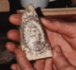
Kathy knows of a sheltered cave with many initials dating from the 1800s. Dean’s friend found a scrimshaw whale’s tooth inscribed with the word “Dakota.” Randy knows of a ring valued at $1,500 found with a metal detector.
Perhaps it is a case where “one man’s trash is another man’s treasure,” but for the last 2500-3000 years the Mississippi River Valley has supported intense human activity. This makes it a particularly historic area, rich in Indian relics. Additionally, relics from the French, English, Spanish and American adventurers who have explored the area since the 1600s are still being found today. Antiques from the first settlers, dating back to the 1760s, are sought by dealers from throughout the country. All of this adds up to great prospecting for the treasure-hunting hobbyists using metal detectors who are active in the area.
Roger Toner (not his real name) owns a snowmobile/cycle shop in the La Crosse area, but his real love for the last 15 years has been treasure hunting. Roger suggests that most hobbyists go “shooting” with metal detectors much as another individual goes fishing – for relaxation.
A good find is an old coin, a bit of jewelry, an iron relic or an Indian artifact. The success of a hunter will likely depend less on luck than on the amount of time spent researching his sites and how well he can use the metal detector.
The big questions for the would-be searcher might be: where to start looking? what equipment will I need? what sort of treasures can I realistically expect to find?
For Roger, the hunt usually starts while snow is covering the ground.
“I find it much easier to visualize how soldiers or hunters might have used the land when all I have to study is the smooth snow-covered earth,” he says. “I think to myself that a particular hump looks out of place or especially convenient. Or that this high flat bench might have made a good camp ground. Then I come back to search in the spring when the frost has forced new artifacts to the surface.”
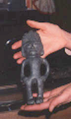
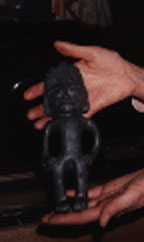
Some of Roger’s best finds have come while “puddling” in the mud of a river bend. “Again, I work in the spring. The water and mud are very cold, but I’ve found perfectly preserved tomahawks, still wrapped in leather. A green stone figure I found has been certified as a Mayan carving in jade.”
The United States Treasure Atlas by Tom Terry provides an introduction to the places treasures are most likely to be found and makes available the data from his years of treasure-hunting research. Reputed treasure sites and ghost towns are listed on a county-by-county basis for each state. A quick glance at any river valley county listings is likely to be enough to whet the appetite of the most cynical.
Old state and county maps are also available in our Shopping Cart which will indicate old roadways, railroad beds and ghost towns. Terry suggests these historic roadways as preferable to modern roads as it is far more likely that valuable coins and relics may be found. Modern parks and roadsides often contain more trash than treasures.
The library and reference librarians are also helpful in tracking down local histories and out-of-print books that might provide the serious seeker with leads. Old newspaper stories provide leads on some of the earliest caches. An article from 1909, for example, details a search of bluffs and s
horelines for a money cache dating from the 1700s thought to be buried near present-day Osceola, Wisconsin, after English adventurer William Snow was attacked by French soldiers. The cache was not
recovered.
Native artifacts are abundant along the Mississippi River shores of Wisconsin, Minnesota, and Iowa.Government forts were established in the early 1800s along the entire length of the Upper Mississippi River. Riverboat captains, soldiers, pioneers, adventurers and traders traveling between the forts often carried large sums of gold or silver coins for payroll or trading purposes, as well as supplies.
The Upper Mississippi River valley is rumored to be heavy with the unrecovered treasure caches of river pirates, gypsies and horse thieves. Indian hostility was rampant until the Battle of Bad Axe north of Prairie du Chien ended the Black Hawk War in 1832. Upon attack (whether from Indian, outlaw or river pirate) valuables were hidden to avoid theft. Often, the transporter was killed and there remained no one who knew just where the treasure had been buried. Victims might be left too short-handed to retrieve the valuables, or natural disasters occurred, such as flood, earth slide or memory lapse.
According to the United States Treasure Atlas, rumors persist that $80,000 was buried in 1832 “on the highest bluff across from Fort Crawford at Prairie du Chien, Wisconsin, in four piles of $20,000 each” during an Indian attack. The soldiers who buried the treasure were ambushed before returning. The treasure was never recovered.
Treasure hunting along the MN, IA, WI shores.
Buried money, jewelry and other treasures are likely to be found wherever people lived; banks were often far away and distrusted. An old home foundation might conceal a “private” bank in the floorboards, or savings might be stashed in a nearby fence posthole or a tin can beside the silo. Dollar bills have been sewn into and under carpets, into linen, drapery, stuffed behind wall-boards and under floorboards and in false air ducts.
The steamboat era has left many relics along the Wisconsin and Illinois shores of the Mississippi River. The great wooden boats that changed the course of commercial history along the Mississippi had a life expectancy of only five years and usually met with an untimely end in sudden fires or sinkings.
Steamboat wrecks have provided authorized divers with a steady stream of antiques, relics and personal belongings. The prized safes from many wrecks remain unrecoverable, including the War Eagle safe off the riverfront in La Crosse, Wisconsin.
Coins found with metal detector.According to Roger Toner a typical treasure
hunt (say in a small cave) would involve the following steps: 1) Take photos of the site before doing any searching. Often things can be seen in the photo which are not apparent to the eye. 2) Use a metal detector to pinpoint any possible coins, jewelry, iron relics. A fork or other very small tool might be used to find the item. A whiskbroom and sifter might be used to search for other relics. If anything of interest is located, make detailed notes of where it was found, as one good find usually means more to come.
Tools other than metal detectors are inexpensive: a fork for making small holes, a sifter, a whisk broom and a probe that looks similar to a giant hatpin. Note that a shovel is not standard equipment. Too often a shovel will simply damage the fragile relic.
The cardinal rule among treasure hunters is get permission before searching on any private or public land. State parks and monuments, national parks and sites and some local parks and monuments are off limits to seekers with metal detectors, as are state-and federally-owned property under the protection of the conservation departments, the Army Corps of Engineers, wildlife refuges, etc. Written permission must be obtained from authorities before removing any relics.
Today’s treasure hunter is made from the same mold as the prospector of old. He or she is a dreamer, an optimist, full of curiosity and appreciation for things past. The thrill is in the search, the chance that the next find will be the big one. Like the gambler, he develops an “itch” to try out the next hot spot.
Roger would rather talk about his hobby than anything else. Terry has been sharing his knowledge with others for the past 10 years. Our farm was settled in 1858 – and I can’t wait for the ground to thaw!
Our brand new Upper Mississippi River travel guidebook, Discover! America’s Great River Road, Volumes 1-4 by Mississippi River author and lecturer, Pat Middleton.
“Orma Remembers Nelson, Wisconsin”
(excerpted from Volume 1 of DISCOVER! America’s Great River Road
“The bluffs were full of caves and I remember wiggling through some of them on my stomach, they were that small. I know people spoke of rattlesnakes, but I never saw one. There was a rumor of treasure buried by soldiers in the bluffs. Often, people just went up and dug around in their spare time hoping to find it. I never heard that any treasure was ever found.” Click here to see ALL our books and antique maps featuring the historic Mississippi River.
Nov. 18… Upper River is shutting down! Pretty much ice-covered. I remember years when I was riding the Steamboats on Nov. 17th! This morning I saw 9 eagles clustered around a small area of open water. This afternoon…. no more small areas of open water!! Eagles are abundant… I must have seen 20 in a 5 mile stetch this morning… but the river tonight is pretty well sealed up. Eagles will be moving to open water just below the dams. Swans and Pelicans evaporated! Waterfowl are still migrating through looking for open water!
Eagle nests are now clearly visible along the river.
………………………………………………………..
Nov. 10……. Have been driving along the Wisconsin shore north and south of La Crosse. Lots of Swans, and other migrating waterfowl! Eagles are also ABUNDANT as the river begins to freeze up before our eyes. My hope is that it will all open up again once the polar vortex is well out of the way, but meanwhile waterfowl and Eagles are abundant in the open water.
As I’ve mentioned earlier, after my river weeks on the American Queen, it is the adult American Bald Eagles that seem most abundant to me. Not nearly the number of juveniles that I’ve seen in late fall in past seasons. http://www.greatriver.com/wordpress/wp-content/uploads/2013/01/watermarked-eagles-300×86.jpgWould love to hear some comments!


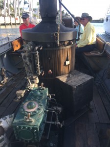 Engine and today’s diesel boiler.


 om the 1800s. Dean’s friend found a scrimshaw whale’s tooth inscribed with the word “Dakota.” Randy knows of a ring valued at $1,500 found with a metal detector.
 which will indicate old roadways, railroad beds and ghost towns. Terry suggests these historic roadways as preferable to modern roads as it is far more likely that valuable coins and relics may be found. Modern parks and roadsides often contain more trash than treasures.
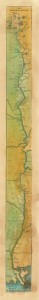 The library and reference librarians are also helpful in tracking down local histories and out-of-print books that might provide the serious seeker with leads. Old newspaper stories provide leads on some of the earliest caches. An article from 1909, for example, details a search of bluffs and s
 The steamboat era has left many relics along the Wisconsin and Illinois shores of the Mississippi River. The great wooden boats that changed the course of commercial history along the Mississippi had a life expectancy of only five years and usually met with an untimely end in sudden fires or sinkings.

