Drainage Map of the Mississippi River and its Tributaries. Some Facts and Figures

QUESTIONS! QUESTIONS!
For Jack, who wants to know more about all the tributaries of the Mississippi River: how many there are,  their names, and how long they are!
NPS.gov watershed tributaries

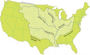
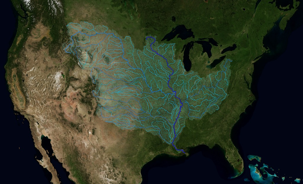
There are some 250 tributaries of the Mississippi which drain a total area of more than 1,247,000 square miles–one third of the nation’s landmass–extending from the Allegheny Mountains in the east to the Rocky Mountains in the west!

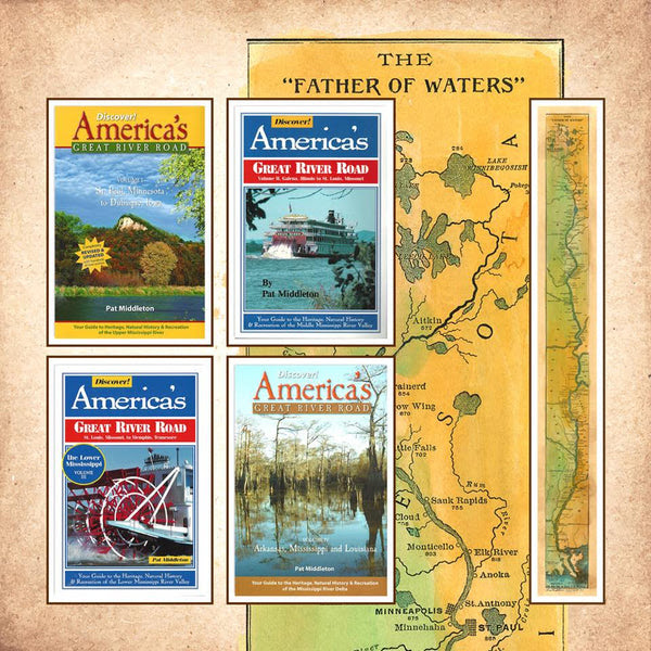
We start here with quick facts on the Mississippi River and several navigable tributaries! Please follow links for a little more depth of historical interest and to see our collection of hand-painted maps!

The Mississippi River, from its source at Lake Itasca in Minnesota, to the Gulf of Mexico, is approximately 2,348 miles long. The combined reach of the Missouri-Mississippi Rivers is 3,741 miles–a length exceeded only by the Amazon and Nile rivers. The Mississippi River has shortened by several hundred miles since the days of Mark Twain. Even today it varies 30-50 miles each year.

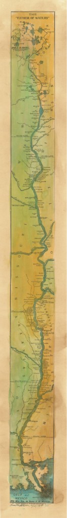
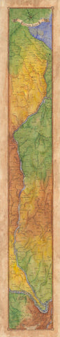
The widest navigable part of the Mississippi is Lake Pepin, on the Upper Mississippi, where it is approximately 2 miles wide. The average current flows from 1.2 miles per hour nearer Lake Itasca, and about 3 mi per hour nearer New Orleans. Our historic Mississippi River Ribbon Map has been a best-selling Gift for many years.

Yes! The Mississippi River map can be ordered FRAMED and delivered to loved ones from Great River Arts as a uniquely treasured Father’s Day or Mother’s Day Gift!

“This is a beautiful map!! My whole life is on this map! My home town, the towns where my kids live, even New Orleans, my favorite place to vacation!”

TRIBUTARIES OF THE MISSISSIPPI River  … Watershed map
U.S. Geological Survey EROS Center


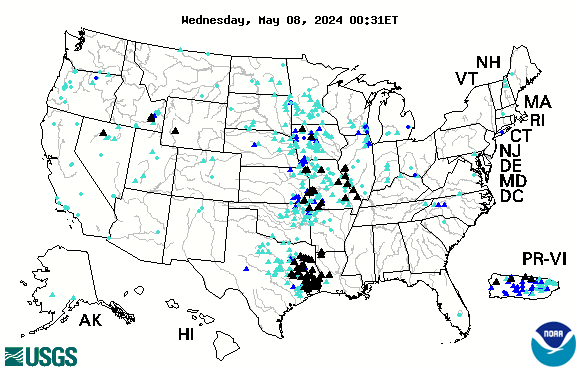
Remember the great Mississippi River Flood of 1993? It wasn’t just the Mississippi River flooding that wreaked havoc, it was that all those tributaries flooded as well! At one point, the volume of water flowing past St. Louis was eleven times the volume of Niagara Falls!! You may also want to check out our interactive map of which of the tributaries are at flood stage today! Click INTERACTIVE MAPS in the category list, right hand column, to see where the tributaries are at flood level TODAY!!

Lisa now offers her own custom ribbon map designs of both the OHIO RIVER and the Missouri River. Please click on any map image for more info on the map or the tributary. Or PHONE 888-255-7726 to order any map. Click on map images for more info on the tributaries.

192 Missouri River Ribbon Map
017 Arkansa Territory 1827
The Arkansas River forms in the Rocky Mountains in Colorado and meanders 1,450 miles through Kansas, Oklahoma, and Arkansas.  It is the main water source for the state of Arkansas.Click here to see
more Arkansas River facts and Artisan Maps by Lisa Midd

/

Ohio River Ribbon Map

The Ohio River is the second major tributary of the Mississippi. It is formed in Pittsburgh by the junction of the Allegheny and Monongahela River and travels about 980 miles to Cairo, Illinois, and the Mississippi River. Interestingly, today’s Ohio River Basin is approximately the northern extremity of the ancient shallow sea that is represented today by the Gulf of Mexico! Consider that nearly 1/3 of the nation’s water drains past the confluence of the Ohio and Mississippi rivers at Fort Defiance in Cairo, Illinois!  

Click here to see more Ohio River facts and Artisan Maps by Lisa Middleton

The Illinois River

Illinois River Ribbon Map

The Illinois River, cutting through steep rocky bluffs, runs approximately 273 miles (439 km), with some 60 miles of scenic water. It flows through the heart of the State of Illinois, and links the great rivers of the American West with the Great Lakes, the St. Lawrence Seaway, and finally the Atlantic Ocean.

Historically, the Illinois River has had a significant impact on the state’s economy, communities, and peoples. Long before Europeans discovered America, indigenous tribes inhabited the Illinois River Valley and settled on the riverbanks, creating a river culture of their own. In 1673, Father Jacques Marquette and Louis Joliet surveyed the region, canoeing up to the Illinois River via the Mississippi River, hoping to find a route linking the Great Lakes to the Illinois River and the Gulf of Mexico. Today, the Illinois and Michigan Canals are the evidence that their vision became reality.

And for fun, checkout our fascinating 1841 STEAMBOAT MAP OF ILLINOIS
lists all the steamboat stops and distances along the Illinois River and the Mississippi, Ohio and Vermillion Rivers!

Wonderful detail!

119 1841 Steamboat Map of Illinois

Planning for an upcoming CRUISE? We’ve featured several of our SMALL BOAT CRUISE destinations here!
WATERWAY CRUISE REPORTS

New Kindle Versions of our Most Popular Steamboat Book…and a Little Something Extra!

If your favorite River Buff has become a Kindle fan, we now have the following NEW Kindle Editions available for Pre-order for Christmas gifting this year!

6CCFCF9F-6FBC-4B3C-8BB3-C2D3CF34E3B1
“Treasure Hunting” has been one of our most requested river topics through the years. Pirates, military trails, payroll caches, old maps and steamboat wrecks have all left tales of sudden death and unrecovered treasures. In the first of our Kindle “INSIGHT Series” we  have collected a number of our previously published favorite treasure hunting stories, how-tos, and resources available to the Treasure Prospector here on the upper Mississippi River.

One Man’s Treasure” is now available for pre-order in the Kindle Store. PRE-ORDER RIGHT HERE, now, just $2.99!

bright Come Hell Cover VOL 1 Kindle
Our ever-popular steamboat anthology, COME HELL OR HIGH WATER by Michael Gillespie is newly available as a quality 2-Volume KINDLE edition. Filled with historic photos, witty commentary, footnotes, bibliography, Glossary and fascinating river facts and stories. Each Volume is purchased separately. 

Volume 1 PRE-ORDER RIGHT HERE.   $9.95

 Volume 2 PRE-ORDER RIGHT HERE.  $9.95


Midwestern Flooding

Much of the central part of the country is currently experiencing dangerous flash floods. See up to the minute status reports for American rivers by clicking on our INTERACTIVE FLOOD LINK in the category list to the right.

us

Looking for more great content, lots of river content available by clicking on any of the category links.


Special Pricing our most popular Book and Map RIVER BUNDLE… Great River Road/Mississippi River Guides and SAVE $30!

Perfect for Gift Giving! Need extra maps? Everyone who loves our 1887 map by Lisa Middleton will love Discover! America’s Great River Road, our comprehensive guide to life along the river for their favorite section!  Just CLICK HERE to purchase additional maps!

All Great River books can be ordered activity coverindividually as well. CLICK HERE to go Straight to BOOKS on our new Shopping Cart at Great River Arts.

Let us know if you have any questions!


INTERACTIVE RIVER MAPS

We are pleased to offer several interactive maps on greatriver.com….  Click on Blue Titles to move to the specific site, or just study the interactive map shown. All maps are constantly updated to reflect real-time activity!

arrow-clip-art-Arrow-clip-art-16CURRENT RIVER FLOOD ALERTS

Below is the USGS map that provides REAL TIME info on which Rivers in the US are cresting. The map below is accurate every day. Black Triangles indicate flood stage. Looking to compare stats with the Flood of 1993? CLICK HERE.

us


Generic picture of a barge on a river coming upon a lock
arrow-clip-art-Arrow-clip-art-16Locate A Vessel By Vessel Name Or Vessel Number

arrow-clip-art-Arrow-clip-art-16 Click Here for a List of  Navigable Amerian Rivers


NAVAGATION CHARTS from USACE

arrow-clip-art-Arrow-clip-art-16 Click Here for Upper Mississippi River Charts. Printable page by page in .pdf format
The Upper Mississippi River Navigation Charts cover the Upper Mississippi River from the head of navigation at river mile 866 in Minneapolis, Minn., to the confluence with the Ohio River at Cairo, Ill. The navigable portions of the Minnesota and St. Croix Rivers are also included. The charts were last updated in 2011.

arrow-clip-art-Arrow-clip-art-16 Click Here to DOWLOAD ENTIRE UPPER MISSISSIPPI RIVER CHART BOOK…. 142 MG   Minneapolis/St. Paul to Cairo, IL  866 River Miles. Also the St. Croix and Minnesota Rivers. Carry it with you on your tablet or laptop computer!

arrow-clip-art-Arrow-clip-art-16Click here for Lower Mississippi River Charts.  Download entire book.

Cairo, Illinois to the Gulf of Mexico. River Miles 953 to 0 at A.H.P.


arrow-clip-art-Arrow-clip-art-16  Click here for Illinois Waterway Charts.
The Illinois Waterway Navigation Charts cover the Illinois Waterway from the confluence of the Illinois and Upper Mississippi Rivers to Lake Michigan at Chicago and Calumet Harbors. The charts have been updated in 2013.


arrow-clip-art-Arrow-clip-art-16 Click here for the USGS EARTHQUAKE HAZARD MAP.

If you enjoy reading about the New Madrid Earthquakes of 1811-12 in Volume 3 of DISCOVER! America’s Great River Road, you will enjoy this interactive map of tremors around the US on a moment by moment basis!

TODAY’s Earthquake Fact:  The Mid-Atlantic Ridge appears above sea-level at Iceland. This offers scientists a natural laboratory for studying on land the processes also occurring along the submerged parts of a spreading ridge. Iceland is splitting along the spreading center between the North American and Eurasian Plates, as North America moves westward relative to Eurasia.

Today in Earthquake History

calendar icon

August 30, 1986
M 6.9, Romania – Damage (VIII) in the Focsani-Birlad area, including the collapse of a church. Felt (VII) at Bucharest. Two people killed, 558 injured,… Read More

Springing Forward!

[adsenseyu1]

With 70 degree days predicted for early next week, we will be seeing more and more of our returning songbirds and waterfowl. Sandhill Cranes, robins, red-winged black-birds, starlings, bluebirds and such are already singing, in addition to Cardinals, titmice and other year-round residents. Sandhills are still very quiet, so they don’t seem to be claiming their nesting territories yet. Send us your comments!!  Click here to see our birding archive on the Ramblin’ On blog. 

With so little snow this winter, spring flooding is unlikely this season. To see an interactive flood map, as well as past flooding accounts, click here.

Snowy Owl with Jane at 2012 Festival of OwlsThe spring 2012 International Festival of Owls was held in Houston, Minnesota, last weekend. It is another harbinger of spring! (Snowy Owl pix, from Alan Stankevitz is left.)

[adsenseyu2]We had a beautiful barred owl in our backyard early one morning last week. Hawks are paired up and bald eagles are nesting. I’ll be watching for the return of white pelicans next… they follow the opening of the Mississippi River… perhaps looking for fish kill as the ice breaks up.

We have featured WHITE PELICANS, EAGLES and other large waterfowl for many years on www.greatriver.com
Please visit our dedicated Birding Index here at Greatriver.com  It includes a long history of arrival dates for the sandhill cranes in the Upper Mississippi River valley.

Could an Earthquake Happen in the Midwestern United States?

A major fault lies below the Mississippi River from Memphis to St. LouisWith all the media coverage of the 7.0 magnitude quake in Haiti
in January 2010, interest has shifted to the USA.

We all think of California immediately, but could it happen
here in the MIDWEST? Think NEW MADRID FAULT,
right under the Mississippi River!

Scientists suggest there is a 25% chance of a 7.5 magnitude quake by the year 2040. A quake of this magnitude would be felt throughout half of the United States and cause damage in twenty states or more.

by Pat Middleton, Volume 3, DISCOVER! AMERICA’s GREAT RIVER ROAD


Intensity map for the New Madrid Fault


    The New Madrid Fault is a major active fault line that runs approximately from Memphis, Tennessee, to St. Louis, Missouri. On Dec. 16, 1811, this area was hit with an estimated 8.6 magnitude quake on the modern-day Richter scale. This was the first of THREE major quakes to rock the Midwest. A second quake on January 23, 1812 is estimated to have been an 8.4. A THIRD shock on February 7, 1812, is estimated to have been the strongest jolt ever to hit the North American continent at somewhere near 8.7 to 8.9.Find extensive details about the New Madrid earthquake fault and the formation of REELFOOT Lake in Volume 3 of DISCOVER! America's Great River Road.

    We pulled some illuminating facts from Volume 3 of DISCOVER! America’s Great River Road…What would an 8.7 magnitude earthquake feel like?

The New Madrid earthquake released energy equal to 150,000,000 tons of TNT. In comparison, the two atomic bombs dropped on Hiroshima and Nagasaki in WWII equaled 35,000 to 40,000 tons of TNT!!


When the tremors and convulsions of the earth subsided, 30 to 50 thousand square miles of land had undergone vast topographical changes. Most of which are visible today. In the northwest corner of Tennessee, land dropped 10 to 20 feet and caused the Mississippi River to flow back upon itself which formed REELFOOT LAKE. In places along the Mississippi River, I have seen sandboils which still lie barren, or waves of undulating earth frozen into the compacted soil.

The New Madrid fault system extends 120 miles southward from Cairo, Illinois, through New Madrid andCaruthersville, Missouri, following I-55 free way system to Bytheville and on down to Marked Tree, Arkansas. Buried five to to ten miles underground (similar in depth to the Haiti quake), it crosses five state lines and cuts across the Mississippi River in three places.

Map showing earthquakes


    THE USGS maintains a real time list of tremors along the New Madrid fault. Click map image  to see the map for today.


Return to our general INDEX of FEATURE STORIES
Return to the MISSISSIPPI RIVER HOME PAGE at 
www.greatriver.com


Stories from SURVIVORS of the New Madrid Earthquake of

1811-1812
related in part from “Reelfoot Lake and the New Madrid Fault” by Juanita Clifton, 1980

Witnesses report that about 2 a.m. on December 16, 18aa, the earth around the little settlement of New Madrid, Missouri, began to rise and fall like waves upon the sea. When the peaks of the waves rolled through the Mississippi River, the river bottom heaved up, emptying the river onto its banks, inundating the shores and leaving some boats on dry land. When the troughs followed, the river rushed back into the hollows with such force that entire groves of trees were drawn out by the roots and thrown into the river.

On dry land, trees bent like heads of grain in the wind, their ranches interlocked, until they were ripped from the ground. Cracks formed in the earth that sometimes ran for MILES. The quake’s ground wave created sunken lands, fissures, and domes. Sand blows eruped sand and belched hot water, fumes, and carbonized wood.

Mattis M. Speed, a river traveler in February, 1812, described his experience.  “We were awakened about 3 a.m. by the violent agitation of the boat accompanied by a noise so terrible it can best be described as the constant discharge of heavy cannon. The banks were falling into the river and the island to which we were tied was sinking. We cut ourselves loose from the island and pulled as far from the banks as necessary to avoid the falling trees. The swells of the river were so deep as to threaten the sinking of the boat with every minute.”

When he pulled out of the maelstrom at New Madrid, he wrote, “The former elevation of the bank was about 25 feet above common water. When we reached it, it was barely 12 or 3 feet. Scarcely a house was left entire, some completely prostrated, others unroofed and not a chimney standing.”

One man described holding to a tree to support himself during a quake. A fissure opened in the ground and both he and the tree fell in. He was unable to climb out of the fissure at that point and was forced to walk along it until an incline allowed him to scramble out. Fissures as deep as 100 feet ran for miles through the countryside.


New Madrid Earthquake Creates Reelfoot Lake

Both Reelfoot Lake, Tennessee,  and St. Francis Lake in Arkansas were formed by the New Madrid Earthquake in 1811, 1812. A citizen from New Madrid, Missouri, wrote in 1816, “Lately, it has been discovered that a Lake was formed on the opposite side of the Mississippi River, in the Indian country, upwards of 100 miles and from one to six miles wide, of a depth of from 10 to 50 feet.”

The epicenter of the quake was about 70 miles southwest of modern Reelfoot Lake and more than 1800 recorded tremors, some of which rang bells on the east coast, followed by the first powerful jolts.

In 1815, Congress passed an act to relieve area inhabitants who found their riverside farms swallowed up or buried in the sand that spewed from the earth. More than 500 earthquake “certificates”, redeemable for up to 640 acres of government land, were allotted. The site of Hannibal, Missouri, was one of the resultant land grants.

The TIPTONVILLE DOME

A dome-like rise in the otherwise perfectly flat land is clearly visible on the west side of Reelfoot Lake, on the road from the Airpark Inn to Tiptonville, Tennessee.  The Tiptonville Dome formed when the land around Reelfoot Lake sank during the earthquake. Above the newly formed depression, the Mississippi River appeared to flow backward when the waters rushed to fill the depression–the center of which is now Reelfoot Lake.

The raising of the dome also created a natural dam that, for a short time, forced the Mississippi River to flow back south upon itself. The same dam trapped water in low swampland in the vicinity of Reelfoot Creek and Bayou de Chien, eventually allowing Reelfoot Lake to form.

Return to our general INDEX of FEATURE STORIES
Return to the MISSISSIPPI RIVER HOME PAGE at 
www.greatriver.com


Entertaining New History of Steam from Michael Gillespie

Great River Publishing is pleased to announce the KINDLE release of Michael Gillespie’s new steam history: 

RAILROAD STORIES..True Adventures, Humorous Tales, and High Melodrama from the Days of Steam [Kindle Edition]

Click on cover image to explore a sample edition ONLINE or to download a sample directly to your Kindle!
In this 340 page collection of old railroading stories, Michael applies his generous wit, dry humor, and historical insights to the school of railroading literature at the height of the steam era … journals, press reports, trade magazines all produced stories meant at the time to entertain readers… but which today offer a compelling folk history from the early days of railroads.

So Much Has Changed!!

Ice fishermenWhat a difference two weeks can make! River is frozen. Swans long gone. Ice Fishermen abound. Eagles will be searching out open areas in the ice field. And while you may see local fishermen out on the ice… BEWARE. River ice cannot be trusted, even from day to day. River currents EAT ice.

A fisherman friend relayed that he used a special truck for ice fishing… the top had been removed so that if he fell through the ice, he could immediately push off and head for the hole.

Well, it happened that he DID fall through, and he immediately swam to the surface break. Current is obviously a great enemy, but hypothermia strikes in minutes.

He found himself sitting on the edge of the fragile ice edge, kicking his feet in the water. He had to logically think, “this is not normal. I SHOULD be freezing to death.”

So he pulled his body up and ran for the highway where he had his “road truck” parked. He made it to the truck, started out onto Hwy 35. He did reach the highway… and stopped right in the path of traffic.

Another driver stopped behind him, realized something must be wrong, and found Harold hypothermic behind the wheel of his truck.

FLOOD OF 2011 May Rival Even 1927

Fox News photo of Birds Point Levee floodway


130,000 acres of agricultural land floods after a deliberate break in the Birds Point Levee south of Cairo.

The FLOOD OF 2011 is threatening to rival the flood of 1927!

I can’t think of a more dangerous place to be in the world just now than at the confluence of the Ohio and Mississippi Rivers! Levees completely encircle the city of Cairo, forming an island during floods and the Mississippi River begins to back up into the Ohio River.

For an INTERACTIVE MAP of where flooding is at its worse, visit www.greatriver.com/FLOOD.htm

Some 60% of the water that flows through the U.S. passes through this confluence, including much of the deep south, via the north-flowing Tennessee and Cumberland Rivers. As this is the 150th anniversary of the Civil War, it is worth noting that General Grant named Cairo Fort Defiance when it was occupied by the Union Army.

See more stats on the major tributaries of the Mississippi River by visiting www.greatriver.com/tribs.htm To follow the progress of high water through the small towns of the Mississippi River, read Discover! America’s Great River Road.