Recent landslides after rains of 9-11 inches have many of us reminiscing about past experiences of landslides, rockslides, and flooding along the Mississippi River. Below is my own memory from very similar flooding in 2007.
Enter FLOOD in the Search button to bring up an interactive map that shows flooding at any moment along America’s major waterways as well as stats and Chronologies from previous years..
August 20, 2007
“Mom, you missed the HUUUgest Storm!”
“Mom, you have to hear what’s happening. I’ll read it right from the newspaper!”
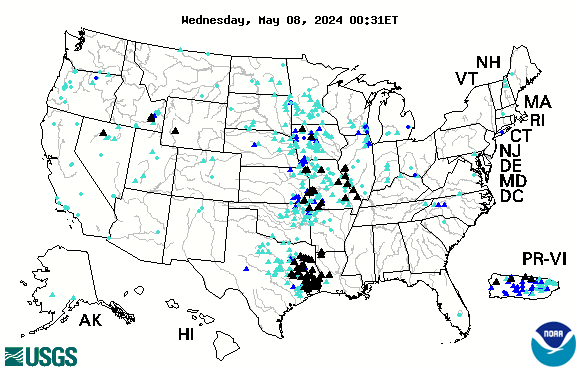
Below is the USGS interactive map that provides REAL TIME info on which Rivers in the US are cresting. The map below is accurate every day. Black Triangles indicate flood stage. Looking to compare stats with the Flood of 1993? CLICK HERE.
See more interactive maps by clicking the category in the list to right: INTERACTIVE MAPS
We are pleased to offer several interactive maps on greatriver.com…. Click on Blue Titles to move to the specific site, or just study the interactive map shown. All maps are constantly updated to reflect real-time activity!
Below is the USGS map that provides REAL TIME info on which Rivers in the US are cresting. The map below is accurate every day. Black Triangles indicate flood stage. Looking to compare stats with the Flood of 1993? CLICK HERE.
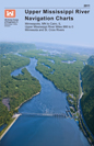
Click Here for Upper Mississippi River Charts. Printable page by page in .pdf format The Upper Mississippi River Navigation Charts cover the Upper Mississippi River from the head of navigation at river mile 866 in Minneapolis, Minn., to the confluence with the Ohio River at Cairo, Ill. The navigable portions of the Minnesota and St. Croix Rivers are also included. The charts were last updated in 2011.
Cairo, Illinois to the Gulf of Mexico. River Miles 953 to 0 at A.H.P.
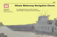
Click here for Illinois Waterway Charts. The Illinois Waterway Navigation Charts cover the Illinois Waterway from the confluence of the Illinois and Upper Mississippi Rivers to Lake Michigan at Chicago and Calumet Harbors. The charts have been updated in 2013.
If you enjoy reading about the New Madrid Earthquakes of 1811-12 in Volume 3 of DISCOVER! America’s Great River Road,you will enjoy this interactive map of tremors around the US on a moment by moment basis!
TODAY’s Earthquake Fact: The Mid-Atlantic Ridge appears above sea-level at Iceland. This offers scientists a natural laboratory for studying on land the processes also occurring along the submerged parts of a spreading ridge. Iceland is splitting along the spreading center between the North American and Eurasian Plates, as North America moves westward relative to Eurasia.
Today in Earthquake History
August 30, 1986
M 6.9, Romania – Damage (VIII) in the Focsani-Birlad area, including the collapse of a church. Felt (VII) at Bucharest. Two people killed, 558 injured,… Read More
OK, as happens almost every year, folks are starting to call about flood conditions along the Upper Mississippi River. Especially with 4th of July holiday around the bend! The image here shows Riverside Park in La Crosse, WI. Basically, the river is plum full and about to start climbing onto the sidewalk. (Thank you Laura Smanski!)
I heard from Davenport, IA, that, yes the riverside has water creeping in, but scheduled events have simply been moved to Higher Ground. Since many campsites along the upper Mississippi River can be impacted by high water, you might want to make a phone call. If sites are available, your reserved site might be moved slightly to higher ground.
Boating of any type is more hazardous in high water. There is lots of debris, including whole trees, flowing by at a mighty quick pace. Canoes and kayaks are not recommended until the river is back to a 6′ stage, rather than the 13+- it is right now. Common Sense is King in high water. Highways, river towns, the Great River Road…not so much to worry about.
Nature’s alarm clock is back on! By 7 a.m. the calls of geese and cranes fill the marsh. Our next waterfowl alert will be the return of the White Pelican.
The pelicans normally follow the melting ice on the river, devouring the fish kill as they move north. Please post your on the comment pages of our Ramblin’ On Blog below!
Spring topics abound in the archives of Greatriver.com… Click HERE for www.greatriver.com birding archives or here for BIRDING archives from our RAMBLIN’ ON Blog. To find a vast array of articles related specifically to Eagles, or Cranes, or other subjects, use our SEARCH engines!
[adsenseyu2]
Though rains and snow were both sparse this year, Spring always means a heightened interest inflood conditions along the Mississippi River. Use our search engine to find interactive flood maps.
Record warmth has also prompted a number of media mentions pertaining to the ICE AGE and past GLACIAL patterns. We’ve done a number of feature stories about past ice ages and the formation of the Mississippi River. Find them here….
With 70 degree days predicted for early next week, we will be seeing more and more of our returning songbirds and waterfowl. Sandhill Cranes, robins, red-winged black-birds, starlings, bluebirds and such are already singing, in addition to Cardinals, titmice and other year-round residents. Sandhills are still very quiet, so they don’t seem to be claiming their nesting territories yet. Send us your comments!! Click here to see our birding archive on the Ramblin’ On blog.
With so little snow this winter, spring flooding is unlikely this season. To see an interactive flood map, as well as past flooding accounts, click here.
The spring 2012 International Festival of Owls was held in Houston, Minnesota, last weekend. It is another harbinger of spring! (Snowy Owl pix, from Alan Stankevitz is left.)
[adsenseyu2]We had a beautiful barred owl in our backyard early one morning last week. Hawks are paired up and bald eagles are nesting. I’ll be watching for the return of white pelicans next… they follow the opening of the Mississippi River… perhaps looking for fish kill as the ice breaks up.
We have featured WHITE PELICANS, EAGLES and other large waterfowl for many years on www.greatriver.com
Please visit our dedicated Birding Index here at Greatriver.com It includes a long history of arrival dates for the sandhill cranes in the Upper Mississippi River valley.
130,000 acres of agricultural land floods after a deliberate break in the Birds Point Levee south of Cairo.
The FLOOD OF 2011 is threatening to rival the flood of 1927!
I can’t think of a more dangerous place to be in the world just now than at the confluence of the Ohio and Mississippi Rivers! Levees completely encircle the city of Cairo, forming an island during floods and the Mississippi River begins to back up into the Ohio River.
Some 60% of the water that flows through the U.S. passes through this confluence, including much of the deep south, via the north-flowing Tennessee and Cumberland Rivers. As this is the 150th anniversary of the Civil War, it is worth noting that General Grant named Cairo Fort Defiance when it was occupied by the Union Army.
I was amazed to read this a.m. of the tornado which destroyed the St. Louis International Airport as well as nearby neighborhoods late Friday night.
Visit www.weather.com for video and forcasts of continuing severe weather through the Easter weekend.
There is about 200% more moisture involved in this stalled front than is normal, which poses a real threat of continuing heavy rain for the next three days. This increases the threat of flooding on the Mississippi and other rivers through the Ohio River Valley.
I have been on the Mississippi River when rains in Kansas caused the Mississippi to raise 30 feet over night… we woke to a river full of floating logs, full sized trees, and other debris picked up by water raising in the back waters.
OK, I love spring because one day (like today) there is a great sense of expectancy… the sun throws long morning shadows, a new bird arrives with every glance out the window (just saw my first starling), they sing in the morning with greater stridency, and the weather is just plain unpredictable.
Well, according to Paul Douglas’s weather blog in Minneapolis, another 12″ snowstorm is predicted for the Tri-State area late next week. Here’s the graphic. Paul’s interpretation follows.
Paul Douglas writes: “Unlike Anything I’ve Ever Seen. This printout is a prediction for total accumulated snowfall between now and midnight, March 19, 2011. Two separate (major) storms: next Wednesday, another very significant snowstorm possible around March 18-19. The GFS prints out a 53″ bullseye over southwestern Minnesota (Windom area), with nearly 30″ for the Twin Cities between these two storms. Good grief. I pray the models are wrong – but I suspect they’re on the right track. I don’t have to tell you what this would mean for our flood potential come April.”
Paul continues, “The models have been surprisingly consistent in printing out over 1″ of liquid precipitation the middle of next week. If the storm tracks across southern Iowa into northern Illinois or southern Wisconsin heavy snow bands may set up directly over southern and central Minnesota and much of northern/western Wisconsin. There is a potential for a foot of heavy, wet snow from this storm. Nothing is guaranteed (except sunrise/sunset), so enjoy the relative peace and tranquility. We’ll probably make up for it next week.”
With all the talk about flooding in June, and continued above average rainfall in July, we are still getting queries about whether it is safe to travel on the upper river.

 We are pleased to offer several interactive maps on
 Illinois and Upper Mississippi Rivers to Lake Michigan at Chicago and Calumet Harbors. The charts have been updated in 2013.


 I was amazed to read this a.m. of the tornado which destroyed the St. Louis International Airport as well as nearby neighborhoods late Friday night.